
Inhaltsübersicht
- Die Frage
- Die Kick-Erfahrung
- Dark Patterns
- Ausstieg
- Wiedereinstieg
- I’m gonna have to science the shit out of this
- 1 Tag später
- Mastodon Mood Board
- Prompts
- 1 Tag zuvor
- 2 Tage später
- Tag der Wahrheit (nach über 300 Posts)
- Wie geht’s weiter?
- Update: 5 Tage später
- Update: 29. Juni 2026
- Beispiel: Christian Stöcker
- Wichtige Auswertungen & Features die nun verfügbar sind
- Beispiele für visuelle Hilfen an den Nutzer bei der täglichen Einordnung
- Beispiele für visuelle Hilfen an den Nutzer in der historischen Gesamtschau
- Mood Board App
- FAZIT
- Nachtrag: Persönliches Fazit
Wann genau ist „Social Media“ ungesund? Das scheint eine einfache Frage zu sein, oder? Derzeit wird diese Frage reduziert auf „Ab wann kann es uns egal sein, ob Social Media ungesund ist?“ aka Alterskontrollen und die Antwort darauf ist von der Politik und anderen die sich nicht weiter zu helfen wissen ungefähr: „So ab Volljährigkeit geht das schon klar.“
Der Blogpost selbst ist komplett von mir geschrieben. Für den Text in meinem Blog setze ich keinerlei AI ein. ABER: Es wird später im Beitrag um AI gehen und eine Applikation die ich mit Hilfe von AI erstellt habe!
Die Frage 
 Die Frage ab wann es ungesund wird, ist vermutlich nicht so einfach zu beantworten, sonst gäbe es aktuell nicht diese ganzen Diskussionen darum, ob man das Ganze nicht für Jugendliche und Kinder verbieten sollte. Andere Länder, wie z.B.
 NeuseelandAustralien haben sich für ein Verbot für Social Media für Jugendliche unter 16 Jahren entschieden.
Folgende Grafik gibt da mal einen detaillierteren Einblick. Quelle: Bundeszentrale für politische Bildung
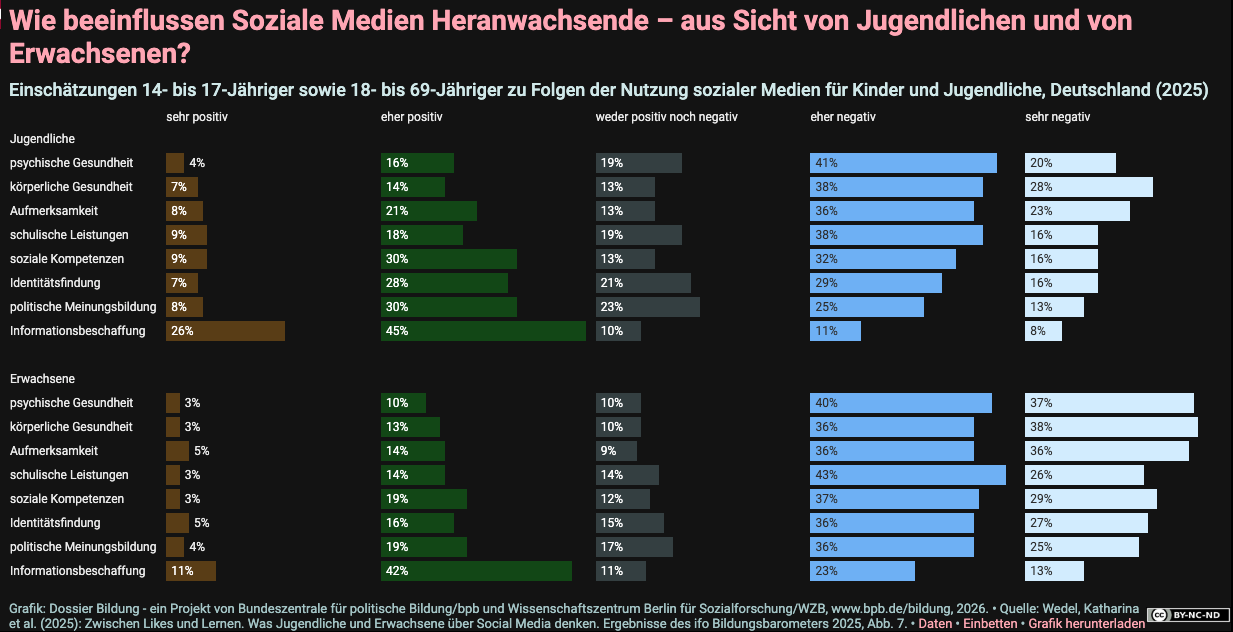
Ich hab das mal etwas komprimiert diese Grafik, um den Blick auf das zu lenken, was diese Grafik visuell ganz an das Ende stellt.
Okay, rechnen wir mal kurz nach für die Jugend: 61% schätzen die psychischen Auswirkungen NEGATIV (wir addieren eher negativ + sehr negativ) ein. 66% schätzen die körperlichen Auswirkungen NEGATIV ein. 59% schätzen die Auswirkungen auf die eigene Aufmerksamkeit NEGATIV ein.
Schauen wir uns die Erwachsenen an, die sind ja volljährig da ist das doch bestimmt besser, oder? 77% schätzen die psychischen Auswirkungen NEGATIV ein. 74% schätzen die körperlichen Auswirkungen NEGATIV ein. 72% schätzen die Auswirkungen auf die eigene Aufmerksamkeit NEGATIV ein.
Löst das Verbot von Social Media in Abhängigkeit vom Alter denn das eigentliche Problem was man lösen will und liesse sich das überhaupt umsetzen? Dafür müsste man mal genauer fragen, was man denn eigentlich lösen moechte. Wenn man da mal genauer nachbohrt, dann sind das ja eigentlich die negativen Folgen von Social Media Konsum und Teilnahme an Social Media Produktion. Etliche Psychologen haben Kinder und Jugendliche in Behandlung, die durch Social Media die Balance im Leben verloren haben. Das wird so jedenfalls berichtet. Könnte daran liegen, dass diese Nutzergruppe SELBST den Gebrauch in Schlüsselbereichen wie psychologische, körperliche und Aufmerksamkeits-bezogenen Auswirkungen zu ca. 60% NEGATIV einschätzt.
Von Erwachsenen, die die Balance im Leben durch Social Media verloren haben hören wir erstaunlicherweise nichts. Vermutlich weil die gleich wegen Depressionen behandelt werden und man dahinter halt so die „allgemeine Belastung“ vermutet. Welche Rolle Social Media dabei gespielt hat, das wird möglicherweise gar nicht erfragt. Die sind ja schliesslich erwachsen!!111 Aber hey, surprise, die Erwachsenen schätzten in den gleichen Schlüsselbereichen wie psychologischen, körperlichen und Aufmerksamkeits-bezogenen Auswirkungen die NEGATIVEN Auswirkungen mit über 70% sogar nochmal +10% schädlicher ein als die Jugendlichen. Huch!?
Die Kick-Erfahrung 
 Nun habe ich einige Zeit damals auf Twitter verbracht (als Twitter noch Twitter hiess und es kaum jemand benutzte). Die Idee war simpel: Kurzbotschaften auf 140 Zeichen begrenzt an die ganze Welt oder seine Kumpels senden. Eigentlich so spektakulär wie SMS auf dem Telefon. Und doch war das Zeug deutlich anders, denn man konnte RETWEETEN und LIKE’N. Mit einem RETWEET wurde der Inhalt an alle FOLLOWER weitergeleitet. Ein LIKE zeigte dem Erzeuger der Nachricht, dass einer seiner Leser es gut findet. Aber letztlich war der RETWEET das ultimative „FINDE ICH GUT!!!“. Andere Reaktionsmöglichkeiten bot die Plattform nicht (z.B. Daumen runter, oder „belastet mich“), es ist durchaus interessant, dass auch facebook damals gegen den Daumen runter entschieden hat, man hat es nur mal getestet, um den Algorithmus etwas zu kalibrieren. Bei twitter gab es das nie.
Dieser Akt der gefühlten Selbstwirksamkeit, quasi mit den Füssen bzw. der Maushand abstimmen zu können, was sich weiterverbreiten sollte und was nicht, gab einem ein Gefühl von „Zünglein an der Waage“ oder auch dem „Scharfrichter“, auf jeden Fall aber hatte man gefühlt einen Einfluss. Wenn man etwas zwar interessant fand aber nicht würdig für einen RETWEET dann tat es auch ein LIKE. Damit hatte man die Nachricht auch für sich selbst quasi gebookmarked, und man konnte seine Favourites später durchsuchen.
Dieses Gefühl selbst etwas bewirken zu können – selbst wirksam zu sein, also selbstwirksam – hatte Suchtcharakter. Es gab einem eine Form von unmittelbar positivem Kick. Ein Dopamin-Ausstoss im Gehirn. Und nach kurzer Zeit wollte das Gehirn mehr von diesem Gefühl. Denn es war doch so einfach… bissel scrollen … bissel was lesen … klicken … Dopamin-Kick.
Doch das BISSEL SCROLLEN wurde dann schnell mal zu eine halbe Stunde scrollen und klicken. Denn das Hirn kann nie genug vom Dopamin bekommen, vor allem wenn es doch so leicht scheint. Scroll-Klick-Dopamin! Easy! Smartphone Apps wie z.B. Twitterific (Screenshot der Website) und Tweetbot (Website, Screenshot der Website) machten das Erlebnis perfekt indem bei einem Retweet, einem Like oder einfach nur dem Refresh, um mehr Inhalte zu laden Sounds abgespielt wurden die fast schon an ein Jump’n Run Spiel erinnerten, bei dem man gerade erfolgreich Goldmünzen eingesammelt hat. Es wurden also auch gezielt Methoden der Spieleindustrie eingesetzt, um das Erlebnis mehr zu einem Spiel & Spass zu machen.
Damals war der Inhalt und das was man als Inhalt präsentiert bekam im wesentlichen bestimmt von anderen Nutzern wie du und ich. Doch das hat sich geändert, erst auf Twitter und dann auf X.
Dark Patterns 
 Twitter hatte angeblich immer Probleme Geld zu verdienen mit dem was sie da anboten. Irgendwann war das auch schon so ein runnig gag, ob die überhaupt jemals damit Geld verdienen würden. Also begannen sie irgendwann Werbung in die Timeline aufzunehmen. Für die App-Nutzer war das kein Problem, die API gab die Tweets ohne Werbung raus. Doch dann wurden peu a peu die Daumenschrauben angezogen. Twitter stellte die API-Zugänge für die Apps ab, denn die Werbung lief ja nur auf der Webseite. Und Werbung wollte man verkaufen und zwar zahlreich. Und an dem Punkt hätte man im Prinzip mit dem „Social Media“ aufhören sollen nach meiner Meinung. Hab ich auch. Heute wissen wir, der Wert von so einer Plattform liegt nicht im Geld eintreiben von „Nutzern“ und „Werbenden“. Der Verkauf der Nutzerdaten (z.B. deren Interessen, was sie gut finden) & die Manipulation der Meinung der gesamten Nutzerschaft (durch Bots & Algorithmen) haben ihren ganz eigenen hohen Marktwert.
 Denn was jetzt kam ist ein Absturz in dunkelste Techniken. Angetrieben durch ein Standardwerk des Silicon Valley das Buch „Hooked (Am Haken): Wie man Produkte herstellt, die süchtig machen.“.
Darin ist beschrieben wie es den Entwicklern mitnichten um soziale Aspekte ging, es ging um knallharte Psychologie. Genau die Psychologie, die Jugendliche und Kinder jetzt in die Behandlung zum Psychologen bringt. Es ging um das psychologische Ausbeuten von Menschen zum Zwecke der Maximierung des Werbeanzeigenumsatzes und des Weiterverkaufs der Nutzerdaten zum Zwecke der Profilbildung.
Das war dann aber noch nicht das Ende denn mit dem Kauf von Twitter das jetzt ‚X‘ hiess, wurde es noch gruseliger. Zu diesem Zeitpunkt waren bereits klare Fakten sichtbar, dass Twitter zunehmend durch Bots (Screenshot) – also automatisch gesteuerte Software – besucht wurde und mit Inhalten beschickt wurde. Die Bots haben natürlich auch gescrollt… das hat Twitter nicht bemerkt oder nicht bemerken wollen. Denn das Geld für gezeigte Werbeanzeigen fliesst dann ja trotzdem. Soll doch der Werber doch erstmal beweisen, dass seine Anzeige nur von Bots angeschaut wurde.
Die naechste Stufe jedoch wurde mit ‚X‘ erreicht, indem man Bots mit Ansage freie Hand liess. ‚X‘ setzte selber Bots ein, um Nachrichten zu pushen oder ganze Inhalte zu promoten. Der Algorithmus wurde angepasst, so dass die Lieblingsthemen von Elon Musk nun viel häufiger in die Timelines der verbliebenen Nutzer gespült wurden. Die Timeline selbst wurde noch härter suechtigmachenden Inhalten (vorwiegend Kurzvideos/Clips) geflutet.
Wer jetzt noch weiter auf ‚X‘ aktiv war, befand sich zwischen Algorithmen, Bots, faschistischen Influencern und Groq, einer neuen AI, die exklusiv in Elon Musks Auftrag an ‚X‘ teilnahm. Künstliche Intelligenz hat dem Ganzen den Extra-Spin verpasst, den es noch brauchte um den Nutzern vollends den Kopf zu verdrehen.
Ausstieg 
Ich hatte da schon längst Twitter verlassen. Aber auch schon davor hatte ich offen gesagt Probleme meinen Twitter-„Gebrauch“ in geordneten Bahnen zu halten. Während der Zeit der Nutzung von Twitter habe ich bestimmt drei oder vier bewusst eingelegte Pausen von der Nutzung gemacht. Weil es mir zuviel wurde! Weil es zuviel Raum einnahm. Weil es mein Gehirn in einen Endlos-Loop aus Scrollen-Klicken-Dopamin gefangen nahm. Und wirklich sozial war daran eigentlich nichts mehr. Aus der Anfangszeit von Twitter, wo man noch über „Microblogging“ sprach – denn zuvor war „Bloggen“ bzw. ein Weblog betreiben eigentlich das grosse Ding gewesen – war nichts mehr übrig. Das Microblogging hatte sich erledigt, denn die Algorithmen übernahmen das Regiment in der Timeline.
Wiedereinstieg 
 Vor einiger Zeit, genauer um 2024 herum habe ich mir dann gedacht, hey, ich probier’s mal wieder, aber diesmal mit Mastodon. Also weder Twitter, noch ‚X‘, noch Facebook, noch Instagram, oder Youtube, oder Pinterest … nur Mastodon, nur eine Instanz. Schliesslich wurde freundlich eingeladen mit „Komm ins Fediverse!“.
Fediverse? Was ist das?
Das Fediverse (aus „Federation“ und „Universe“) ist ein dezentrales Netzwerk unabhängiger Server, die über offene Protokolle wie ActivityPub miteinander kommunizieren. Nutzer:innen können auf einer Plattform ein Konto haben und trotzdem mit Personen auf anderen Plattformen interagieren – ähnlich wie bei E-Mails.Im Gegensatz zu zentralen Netzwerken wie Facebook oder Instagram gibt es keine zentrale Kontrolle, die Daten bleiben oft auf dem eigenen Server („Instanz“), und viele Plattformen sind Open Source.
Quelle: joinfediverse.at
Wenn man anfängt ist es wie damals bei Twitter anfangs, man kennt niemanden und muss eigentlich erstmal rausfinden wo sich alle rumtreiben. Das ist mit Mastodon schwieriger, weil es zig dezentrale Instanzen gibt (was gut ist, so hat nicht eine einzige maechtige Person alle anderen in der Hand). Aber es ist schon ein wenig mühsam. Eine vorkuratierte Timeline gibt’s nicht, ausser die öffentliche (sofern die zugänglich gemacht wird) der lokalen Instanz auf der man ist. Da sieht man dann aber wirklich alles und das überfordert einen sofort. Man sieht tausend Dinge die einen nicht interessieren oder gar aufregen. Also baut man sich über die Zeit eine eigene „Bubble“ wem man „folgt“. Ich finde das Wort „folgen“ tatsächlich schon schwierig.
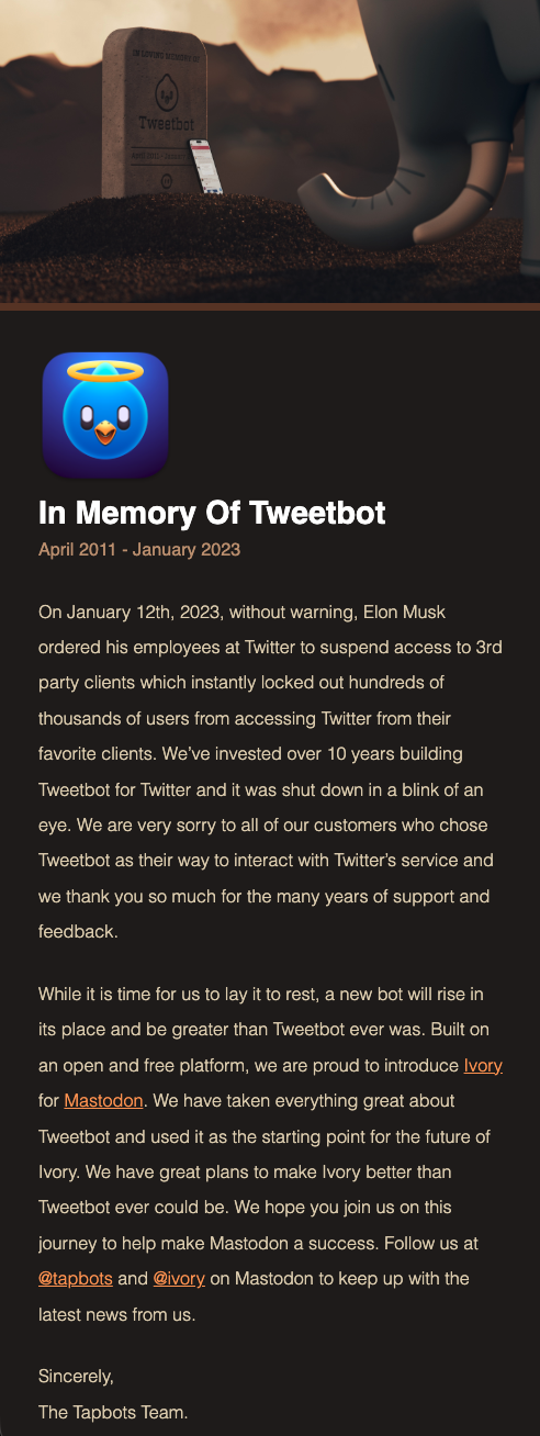
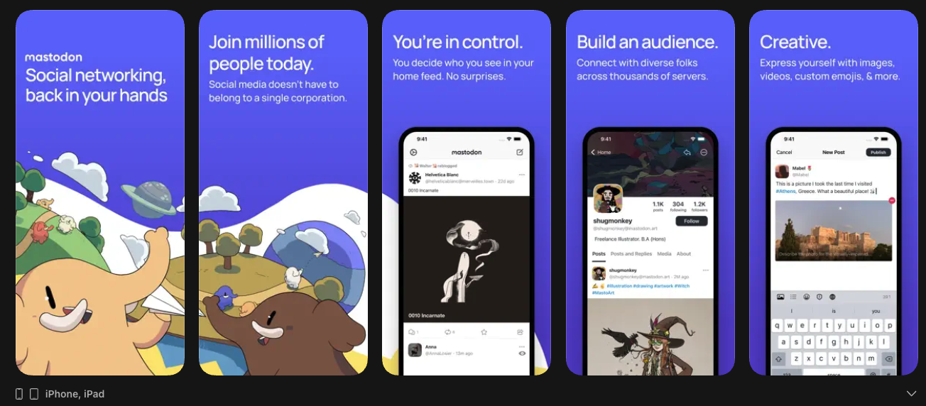
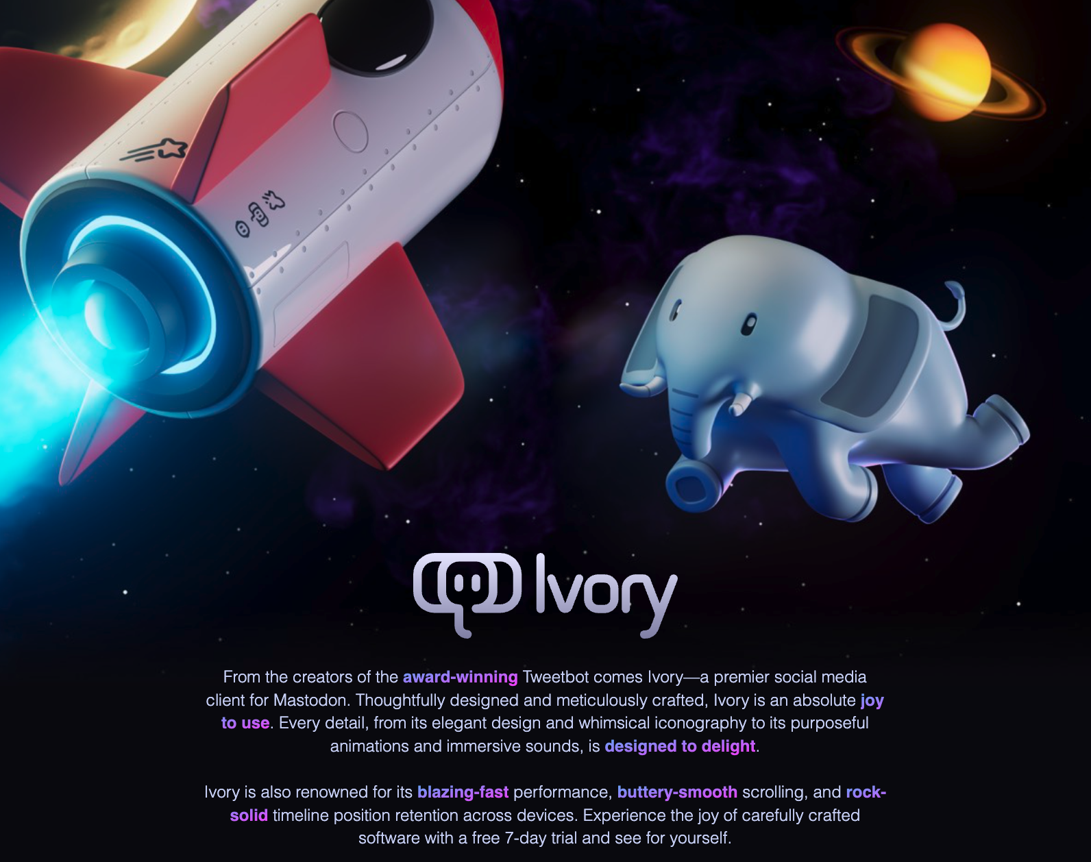
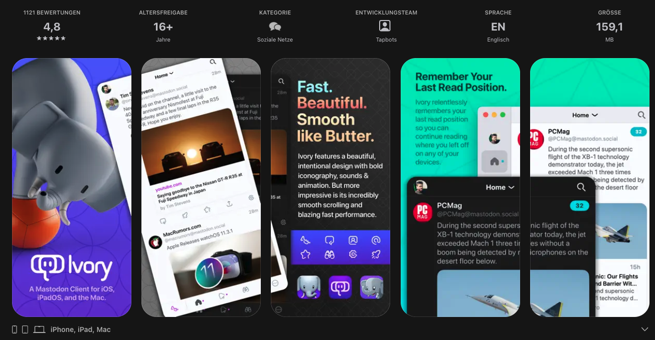
Ich habe ab Mitte 2025 Mastodon dann überhaupt erst einigermassen benutzt. Erst mit der meiner Meinung nach schlechten Mastodon App (Screenshot) unter iOS die bei mir ständig Fehler in der Darstellung & beim Scrolling hatte und mit regemlmässigen Abstürzen zu kämpfen hatte. Kurz, die App machte keine Freude, was eigentlich gut war, denn das begrenzt die Verweilzeit in der App. Dennoch hats irgendwann genervt und ich hab ein Abo für Ivory (Screenshot Website, Screenshot AppStore, AppStore) abgeschlossen. Das ist im Prinzip der Tweetbot für Mastodon (vom selben Entwickler, dem Twitter ja den Stecker gezogen hatte).
Jetzt kostete mich das Social Media nicht nur Zeit sondern auch noch richtig Geld jeden Monat (Tweetbot war damals noch ein Einmalkauf). Fast forward Mai 2026, ich bemerke, wie ich mehr und mehr Zeit an die Ivory App verliere. Das Hirn will Scrollen-Klicken-Dopamin! Aber was beängstigender ist, ich bekomme richtig schlechte Laune. Und ich vermute den Zusammenhang mit der Nutzung von Social Media. Dabei sollte doch Mastodon das „gute“ Social Media sein.
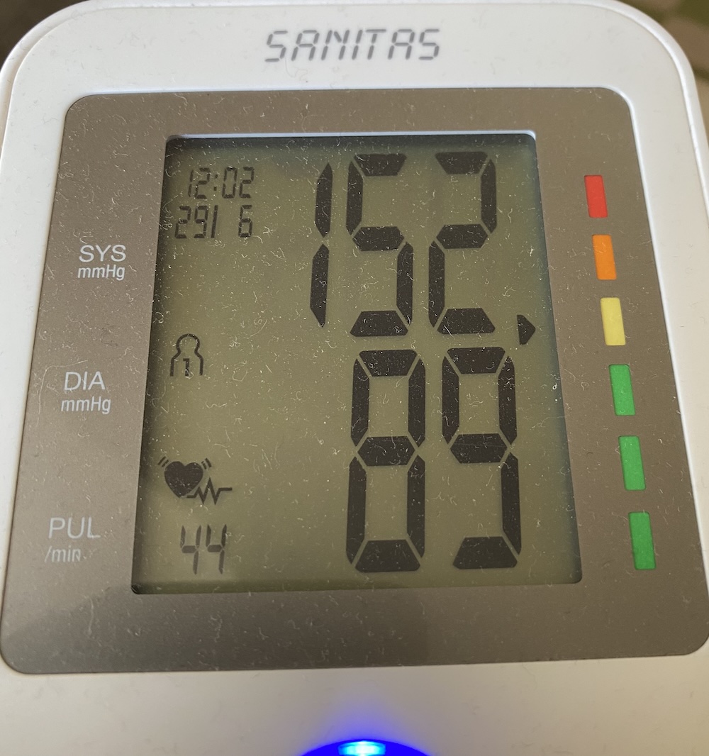
Meine Physiologie sagt anderes, ich habe Bluthochdruck, scrolle wie wild in der App den ganzen Tag und die Nachrichten darin fangen an mich mehr und mehr aufzuregen. Irgendwas läuft hier gewaltig schief grade…
I’m gonna have to science the shit out of this. 
 Um es mit einem Zitat aus dem Film „Der Marsianer“ von Astronaut Mark Watney (gespielt von Matt Damon) zu sagen, „I’m gonna have to science the shit out of this.“
Und genau das ist was derzeit tue, bzw. 2 Tage lang exzessiv betrieben habe. Ich tracke meinen Social Media Gebrauch nicht nur, sondern ich erfasse ihn wissenschaftlich. Um das tun zu können, habe ich mir zunaechst eine Web-Applikation erstellt. Denn für mich stellte sich vor allem eine Frage: „Warum macht mein Social Media Gebrauch mir schlechte Laune?“
Um dieser Frage auf den Grund gehen zu können liegt es für mich nahe, dass ich gezielt mal untersuche, welche Emotionen der Gebrauch von Social Media bei mir auslöst. Doch wie will ich das erfassen? Soll ich einen Zettel neben mir haben während ich durch die Postings scrolle und dann Notizen machen wie "Meh, dieser Post von Netzpolitik.org nervt mich"? Das ist nicht machbar! Doch was genau wäre machbar?
Wenn ich doch nur während ich die Postings lese, eine Einordnung vornehmen könnte, was der jeweilige Post-Inhalt bei mir auslöst. Das wäre hilfreich. Doch der iOS Client Ivory kann das nicht. Eine eigene iOS App schreiben – nur dafür – niemals, ich kann das zwar, aber soviel Lebenszeit ist es nicht wert.
Hmm… aber da ist doch dieses offene Protokoll, und Mastodon hat eine saubere API. Damit müsste sich doch was anfangen lassen. Ich erinnere mich an Mastowall von Ralf Stockmann. Der hat die neuste Release von Mastowall ge-vibe-coded nach eigenen Angaben. Hmm, dann müsste es doch theoretisch…
Ich habe AI benutzt. Ich habe Geld dafür ausgegeben. Ich habe meine gesamte Erfahrung (Jahrzehnte) als Software Engineer in die geschickte Formulierung einiger Prompts gesteckt. Ich habe eine tolle Applikation als wissenschaftliches Hilfsmittel erhalten, mit Hilfe von AI, die ich ohne diese Tools niemals in der Form und der kurzen Zeit (
1 Tag später 
![]() Ich will eine Lösung. Ich moechte belastbare Fakten haben. Also schlucke ich die Kröte und besuche die AI-Platform, die mich vor einigen Monaten bereits bei einem kostenlosen Ausprobieren beeindruckt hatte: LOVABLE.DEV. Das ist ein Service, der eine vollständige, hochintegrierte AI-„Entwicklungsumgebung“ bereitstellt im Browser. im Studium sprachen wir damals noch von Computer Aided Software Engineering (CASE), doch das hier ist was anderes. Das hier ist AI-aided Software Production (AISP).
Ich will eine Lösung. Ich moechte belastbare Fakten haben. Also schlucke ich die Kröte und besuche die AI-Platform, die mich vor einigen Monaten bereits bei einem kostenlosen Ausprobieren beeindruckt hatte: LOVABLE.DEV. Das ist ein Service, der eine vollständige, hochintegrierte AI-„Entwicklungsumgebung“ bereitstellt im Browser. im Studium sprachen wir damals noch von Computer Aided Software Engineering (CASE), doch das hier ist was anderes. Das hier ist AI-aided Software Production (AISP).
Mit einem anderen Account hatte ich auf lovable.dev bereits einen ersten Proof-of-Concept produzieren lassen mittels AISP. Dann gingen mir die 5 Free Credits aus, aber der Prototyp funktionierte bereits ganz gut. Ich wollte aber nicht mit dem Prototyp weitermachen und auch nicht mit DEM Account. Jetzt sollte es produktiv und ernst werden. Also habe ich einen neuen Account angelegt und meine Kreditkartendaten eingegeben. 25 Euro pro Monat, für 100 Credits. Wie weit mich so ein Credit bringen würde? Keine Ahnung. Die kostenlosen Probiercredits (man bekommt 5 davon pro 24h) waren nach gefühlt 3-4 Anfragen aufgebraucht. Spannend war, dass ich allein mit den 5 Free Credits bereits was vollständig Funktionierendes hatte.
Mastodon Mood Board 
Also fing ich an meine Anforderungen zu formulieren. Und das schaut tatsächlich deutlich einfacher aus als es wirklich ist. Denn was man letztlich abliefern muss ist ein Pflichten-/Lastenheft, das alle Anforderungen so präzise formuliert, dass sie eindeutig sind und nicht „missverstanden“ bzw. mehrdeutig ausgelegt werden können. Die Maschine dahinter „liebt“ klare und exakte Anweisungen (nach meiner ersten Erfahrung mit AI’s). Was man ihr nicht sagt, das füllt sie mit eigenen „Vorstellungen“ bzw. mit dem was die Heuristik (entstanden aus dem Modelltraining) an der Leerstelle für am wahrscheinlichsten & plausibel hält. Das muss nicht unbedingt ins Verderben führen, aber meistens ist es eben nicht genau das was man da moechte. Manchmal hat man aber auch Glueck und es ist exakt das was man sich vorgestellt hat… per Zufall (durch die Wahrscheinlichkeit die sich am Durchschnitt orientiert). Was mir schnell auffiel war, dass die AI Leersetllen die ich unbewusst gelassen hatte, oftmals sinnvoll füllte. Das betrifft z.B. Beschriftungen von UI-Elementen, die ich nicht explizit erwähnt hatte, die sie aber dennoch eigenständig erstellte.
Ich fühlte mich an das Gymnasium erinnert, meine alte Schule. Siebte Klasse Gymnasium bei Frau Geissler, meiner Deutschlehrerin. Ich lernte Bildbeschreibungen. Das wichtige an Bildbeschreibungen war die Exaktheit, so dass man sich vorstellen konnte was auf dem Bild wirklich ist. Genauso fühlte sich das an, nur dass ich das Bild nicht hatte. Ich musste die Bildbeschreibung für ein Bild schreiben, das nur teilweise in meinem Kopf existierte. Erst wenn ich die erste Skizze vor mir gesehen hatte, wurde mir klar, „Uff da fehlt aber noch was!“.
Exkurs Bildbeschreibung
Eine gute Bildbeschreibung gliedert sich in Einleitung, Hauptteil und Schluss.
Einleitung
In der Einleitung nennt man die wichtigsten Grunddaten zum Bild: Art des Bildes, Thema oder Motiv und, falls bekannt, Künstler oder Quelle.
Hauptteil
Im Hauptteil wird das Bild genau und geordnet beschrieben, meist vom Allgemeinen zum Besonderen.
- Vordergrund, Mittelgrund und Hintergrund.
- Personen mit Aussehen, Kleidung und Haltung.
- Gegenstände, Umgebung, Farben, Licht und Perspektive.
Schluss
Im Schluss kann man die Wirkung, Stimmung oder eine vorsichtige Deutung des Bildes formulieren, wenn dies erlaubt ist.
Tipps
- Das Bild zuerst genau betrachten und Stichpunkte notieren.
- Die Beschreibung klar gliedern und in ganzen Sätzen schreiben.
- Vom Großen zum Kleinen oder von wichtig nach weniger wichtig beschreiben.
- Im Präsens schreiben und Wiederholungen vermeiden.
Quelle: lernhilfe-sprenger.com
Also fing ich an meine genaueste „Bildbeschreibung“ zu formulieren, die ich je geschrieben hatte. Es fühlte sich an wie in der Klassenarbeit damals in Deutsch. Hier also meine Beschreibungen…
Prompts 
Prompt 1
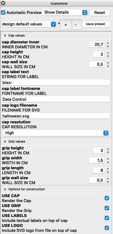
Lass Lovable eine Web-Applikation bauen, die mit dem API von mastodon-Servern interagieren kann. Folgende Dinge soll die Applikation können (anklicken zum ein-/ausklappen)
(anklicken zum ein-/ausklappen)* Sie soll sich mit dem API eines mastodon-Servers in Verbindung setzen koennen, um die aktuellsten Posts dort zu lesen und dann in einem eigenen UI rueckwaerts chronologisch sortiert (aktuellster Post oben) darzustellen. * Hierfuer soll der Nutzer aus einer Liste moeglicher (ueblicher) mastodon instanzen auswaehlen koennen, mit welcher instanz er interagieren moechte. * Neben jedem posting soll es einen Button geben mit der Aufschrift "Einordnung". * Klickt man auf diesen Button, dann soll sich ein Popover oeffnen, in dem man dieses Posting einer oder mehrerer von folgenden Kategorien zu den gefuehlten Emotionen zuordnen koennen soll: Positiv, Negativ, Neutral, Apellierend, Fordernd, Schlechte Laune, Gute Laune, Freude, Schadenfreude, Handlungsdruck, Schlechtes Gewissen, Gutes Gewissen, Aussenseiter, Angst, Befluegelung, Bestaerkend, Liebend * Wenn man in dem popover nichts auswaehlen moechte, soll man es schliessen koennen mit einem "Abbrechen"-Knopf und einem Schliessen-X in der rechten oberen Ecke des popover * Sowie eine oder mehrere Kategorien fuer ein posting ausgewaehlt wurden soll man das popover mit einem "Fertig"-Button schliessen koennen, die Einordnung soll zusammen mit dem unique Identifier des Postings im lokalen Browser storage gespeichert werden. * Die Applikation soll eine Moeglichkeit fuer einen Administrator vorsehen, diese Liste an Kategorien waehrend des Betriebs anzupassen, also welche hinzufuegen zu koennen oder entfernen zu koennen. * Der Administrator muss nicht als extra Account existieren, es reicht ein hart kodiertes Passwort zum Schutz der Administrativen Funktionen. * Nutzer die mit der Applikation interagieren werden mittels eines Cookies identifioziert und ihre Einordnungen von postings werden verknuepft mit ihrer unique UserID die per zufall erstellt wird beim ersten interagieren und dann in einem cookie gespeichert wird. * Der Nutzer wird bei erstmaliger Nutzung darum gebeten einen Vor- oder Nicknamen einzugeben fuer sich selbst, auch dieser wird in den Cookies gespeichert * Die vom nutzer getroffene gemachte Auswahl aus den mastodon-instanzen wird ebenfalls in einem Cookie gespeichert * Fuer die grafische gestaltung greife bitte auf existierende CSS-frameworks wie Bootstrap zurueck. * Stelle die posts dar in einer rechteckigen Kachel mit runden Ecken und leichtem Schattenwurf mit dem entsprechenden Absender, der relativen Zeit von wann der post ist (z.B. "vor 1 Minute", "vor 2 Stunden", "Jetzt gerade" fuer Posts der letzten 60 Sekunden), platziere in die linke obere ecke der kachel das Bild des nutzers in einer kreisfoermigen Maskierung * Sollte ein Nutzer sein post mit einer Content-Warnung versehen haben, dann zeige den post nicht sofort an, sondern stattdessen den text "Inhalt mit Warnung! (Anklicken um inhalt zu sehen)" und zeige den inhalt erst, wenn der Nutzer bewusst auf diesen text klickt. * Fuer den Nutzer stelle Ganz oben in der Applikation drei bereiche dar: "Posts", "Auswertung", "Nutzer", "Admin" * "Posts" zeigt den bis hierher beschriebenen Funktionsbereich * "Auswertung" wechselt den Anzeigebereich und zeigt eine statistische Auswertung aller bisher einkategorisierten postings. Diese Auswertung zeigt wahlweise ein horizontales barChart in dem die kategorien absteigend (Haeufigste zuerst) aufgelistet werden * Der "Nutzer" bereich erlaubt zwei operationen: Das Eingeben, Aendern und Speichern der Nutzer Vor- oder Nicknamen und die Loeschung bzw. den Reset aller gemachten Einordnungen * Der "Admin" bereich erlaubt nach Abfrage eines passwort die Modifizierung der Kategorien (Hinzufiegen, Loeschen, Umbenennen) und die Speicherung dieser Kategorien. Diese Speicherung muss ausserhalb des browsers erfolgen, damit sie persistent fuer alle Nutzer zur verfuegung steht
Prompt 2
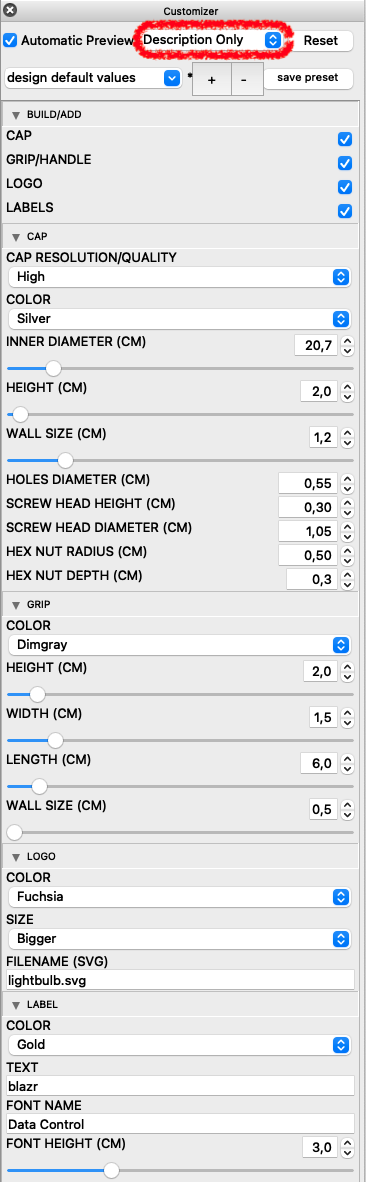
Das schaut schon ganz gut aus, aber folgende Ändrungen und Erweiterungen sollten nun stattfinden
(anklicken zum ein-/ausklappen)
* In dem bereich "Admin" erlaube eine Sortierung der Kategorien durch den Administrator und speichere diese Sortierung nach jeder Aenderung der Sortierung. Die Sortierung sollte einfach per Drag and Drop durch verschieben der Kategorieeintraege funktionieren
* Bitte merke dir die Mastodon-Instanz sobald der Nutzer in dem Dropdown eine mastodon instanz gewaehlt hat die keinen Fehler 422 erzeugt.
* Sofern der Fehler 422 auftaucht, beschreibe bitte fuer den nutzer verstaendlich was dieser fehler ist und was man tun kann um ihn zu vermeiden.
* Fuege vor dem Dropdown zur Auswahl des der mastodon-Instanz einen deutlichen hinweistext ein mit dem Inhalt: "Bitte wähle eine Instanz aus, auf der du bereits gültig eingelogged bist."
* Fuege neben dem Dropdown zur Instanzauswahl einen Knopf hinzu mit der Aufschrift "Mastodon Instanz manuell eingeben...". Klickt man darauf, dann kann man statt aus dem dropdown auszuwaehlen eine Instanz-URL direkt eingeben. Fuelle das Eingabefeld mit einem Beispielwert, der anzeigt in welchem Format die Eingabe erwartet wird.
Prompt 3
Diese Änderungen waren ganz gut, folgende Veränderungen sollten nun noch geschehen:
(anklicken zum ein-/ausklappen)
* Wenn eine Mastodon-instanz ausgewaehlt wurde von der erfolgreich Posts geladen werden konnten, speichere diese instanz bitte in den Cookies fuer den nutzer als default instanz und waehle sie wann immer die "Posts" seite aufgerufen wird als standardauswahl.
* Um von Zeit zu Zeit neue Posts zu laden, stelle oben rechts auf der "Posts"-seite einen Button bereit "Posts nachladen...". klickt der nutzer darauf, dann lade erneut posts von der ausgewaehlten instanz.
* Auf der ersten Seite (nennen wir sie "Willkommen"-seite) fuege bitte einen gut sichtbaren Begruessungstext ein mit folgenden Inhalten:

 * Ueberschrift erster ordnung: "Mastodon mood Board"
 * Ueberschrift zweiter ordnung: "Willkommen, $nutzername!" fuer $nutzername fuege bitte bereits in den Cookies gespeicherten Nutzernamen ein sofern dieser vorliegt, ansonsten benutze den text "Willkommen!"
 * Fliesstext: "Dieses Werkzeug hilft dir deinen Social media Konsum einzuordnen. Gib nachfolgend deinen Vor-/Nicknamen ein und wähle anschliessend deine Mastodon-Instanz aus."

* Auf der "Posts" seite fuege oben einen gut lesbaren hinweistext ein, der dem nutzer erklaert, dass er hier jedes posting mit dem "Einordnen" button emotionalen kategorien zuordnen kann. er kann jederzeit in die auswertung gehen, um sich seine bewertungen anzuschauen.

* Bitte veraendere die Nutzererfahrung dahingehend, dass wenn man die "Posts"-seite kurz verlaesst um z.b. zur "Nutzer"-seite zu wechseln, der kontext der "Posts" seite erhalten bleibt und nicht wieder von von beghonnen werden muss

* Die "Nutzer" seite sollte in dem eingabefeld fuer den Nutzernamen bereits beim aufrufen der seite den in den cookies gespeicherten namen im eingabfeld zeigen. erst wenn in dem eingabefeld eine aenderung erfolgt mit anschliessendem "Speichern", soll der wert fuer den nutzernamen im cookie auch geaendert werden.
Prompt 4
Damit diese Mood Board Applikation ihren Sinn noch besser erfüllen kann, sollten folgender Änderungen erfolgen
(anklicken zum ein-/ausklappen)
* Im "Admin"-bereich erlaube fuer jede kategorie zusaetzlich folgendes Merkmal als boolschen wert zu speichern: "emotion_category" mit den wertauspraegungen "0" fuer negativ und "1" fuer positiv indem du in der eingabezeile fuer die kategorie zwei radio-buttons unterbringst mit den labels "Positiv" und "Negativ". wenn eine neue kategorie erstellt wird, hat dieses merkmal by default den wert "0" fuer negtiv und der radiobutton mit dem label "Negativ" ist bereits vorselektiert. beide radiobuttons gehoeren zu einer radiobuttongroup. sobald der gewaehlte radiobutton verandert wird speichere diese andereung in der kategorie sofort. Je nachdem welche Zuordnung eine Kategorie hat, stelle dem Kategorienamen auf einem hintergrund der farbe "Babyblue" dar fuer kategorien die das merkmal "negativ" tragen und stelle den Kategorienamen auf einem hintergrund der farbe "Cerise" dar fuer kategorien die das merkmal "positiv" tragen. aktualisiere diese farbliche unterscheidung sofort wenn sich die zuordnung zu positiv oder negatriv aendern sollte in den radiobuttons.

* in der "Auswertung"-seite erzeuge statt bislang einem nunmehr zwei barcharts. Beide Barcharts werden nebeneinander angezeigt in einer kacheloptik mit runden ecken und einem leichten schattenwurf dahinter. Das linke barchart hat die Ueberschrift erster Ordnung "Negative Einordnungen" und wertet nun nur noch die Kategorien aus die das merkmal "negativ" tragen und benutzt ausschliesslich die farbe "Babyblue" fuer die balken. Das rechte barchart hat die Ueberschrift "Positive Einordnungen" und wertet nur die kategorien aus die das merkmal "positiv" tragen und verwendet ausschliesslich die farbe "Cerise" fuer die balken.
Prompt 5
Bitte führe ein Refactoring durch, dass u.a. folgende Schwerpunkte hat
(anklicken zum ein-/ausklappen)
* Versuche die verwendeten Komponenten und Libraries und Frameworks soweit wie moeglich zu verringern.
* Versuche die Abhaengigkeit von fremden Softwarekomponenten zu verringern
* Versuche den erzeugen Code in modulare Funktionen zu unterteilen, die du mit passenden kommentaren versiehst
* Versuche das gesamte Projekt technisch zu vereinfachen, so dass man es mit wenig aufwand auf einem lokalen Rechner mit Linux oder macOS installieren koennte
* passe folgende Texte nochmals an:
- "Mastodon mood Board" wird "Mastodon Mood Board" (da war in tippfehler drin, entferne bitte das emoji symbol)
- "Dieses Werkzeug hilft dir deinen Social media Konsum einzuordnen. Gib nachfolgend deinen Vor-/Nicknamen ein und wähle anschliessend deine Mastodon-Instanz aus." wird "Dieses Werkzeug hilft dir deinen Social Media Konsum besser einzuordnen. Gib nachfolgend deinen Vor-/Nicknamen ein und wähle anschliessend deine Mastodon-Instanz aus."
1 Tag zuvor (Proof-of-Concept) 
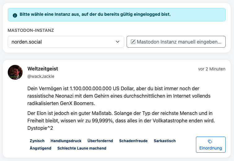
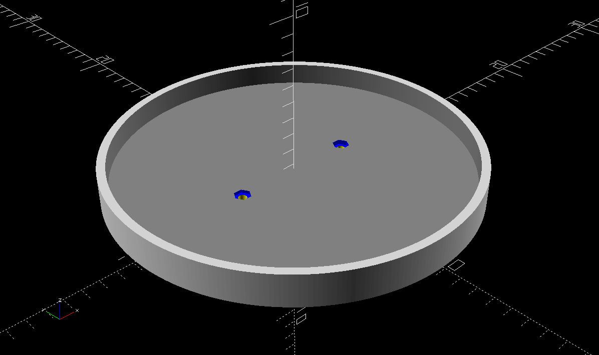
Nach der Abfolge von Prompts an Tag 1 hatte ich tatsächlich eine funktionierende Version 1.0 die alle Basics konnte die mein Proof-of-Concept (PoC) auch konnte. Mit dem PoC hatte ich bereits begonnen Posts einzuordnen. Ein erstes Ergebnis war das was folgender Screenshot zeigt.
Hier sieht man mal eine Beispieleinordnung aus dem PoC. Unten im Posting sieht man welche Einordnungen ich vergeben habe. Da fiel mir schon auf, dass ich präziser in den Anweisungen werden müsste, denn die Einordnungen waren schlecht optisch auseinanderzuhalten ob sie positiv oder negativ waren.
2 Tage später 
Während die obigen Prompts noch die Genese des ersten Proof-of-Concept beschreiben, sahen meine Prompts im zweiten Anlauf deutlich besser strukturiert aus. Es gibt vermutlich eine beste Struktur für „AI-Bildbeschreibungen“ bzw. Arbeitsanweisung im Sinne von AISP (AI-enabled Software Production).
Die neuen Prompts lasse ich hier mal aus, das waren einfach deutlich mehr (und es ist erstaunlich kompliziert diese aus der LOVABLE Plattform wieder zu extrahieren, also richtig viel Arbeit!). Danach hatte ich jedoch eine neue Applikation in den Händen die sogar Light-/Dark-Theme beherrschte. Mit den neuen Bereichen die ich definiert hatte war ich sehr zufrieden. Jetzt musste nur das mit der richtigen Anmeldung als Third-Party-App bei der Mastodon-Instanz noch klappen.
Wenige Prompts später (ich glaub es waren zwei) klappte auch die Anmeldung bei meiner Instanz (oAuth-Tokens bekommen und einsetzen), und ich konnte meine Timeline-Posts drauflos einordnen. Während des ersten Prototypen hatte ich die positiven und negativen Kategoriemöglichkeiten nicht sehr konsistent vergeben. Das war eine wilde Mischung aus Bewertung des Inhalts und Emotionen, das sieht man in dem Screenshot oben auch. Ich wollte jedoch (erstmal) nur die Emotionen sauber erfassen. Wenn ich Äpfel mit Birnen vermische, ist das einer echten Auswertung nicht zuträglich.
Also habe ich eine Liste an Emotionen zusammengestellt, die höchstwahrscheinlich am häufigsten in diesem Kontext auftauchen können. Das ist natürlich erstmal eine recht willkürliche Auswahl. Ich habe dennoch versucht eine vor allem ausbalancierte Auswahl an Emotionen zu haben. Und ich wollte genauso viele negative wie positive zur Auswahl haben. Folgende Emotionen habe ich also in die Einordnungskarte aufgenommen.
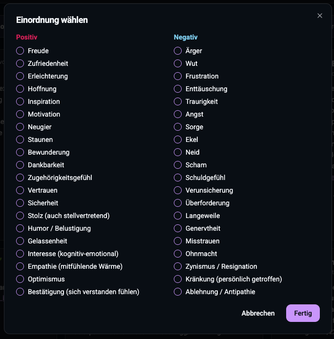
Man sieht das ist jetzt deutlich konsistenter. Es sind alles Emotionen und eine ganze Bandbreite davon. Das Gute ist, ich bin nicht darauf festgelegt für immer. Ich kann das Set an Emotionen verändern im Admin-Bereich. Sowohl inhaltlich (neue Kategorien hinzufügen, bestehende umbenennen oder löschen) als auch in der Struktur, die Sortierung für die Anzeige in der Einordnungs-Karte. Das war mir wichtig und es lässt die Möglichkeit offen, das auf Basis wissenschaftlicher Literatur nochmal später zu verbessern, oder besser zu kalibrieren. Ganz konkret fällt mir dazu das Paper „Evidence for a Three-Factor Theory of Emotions“ von JAMES A. RUSSELL, University of British Columbia und ALBERT MEHRABIAN, University of California, Los Angeles ein.
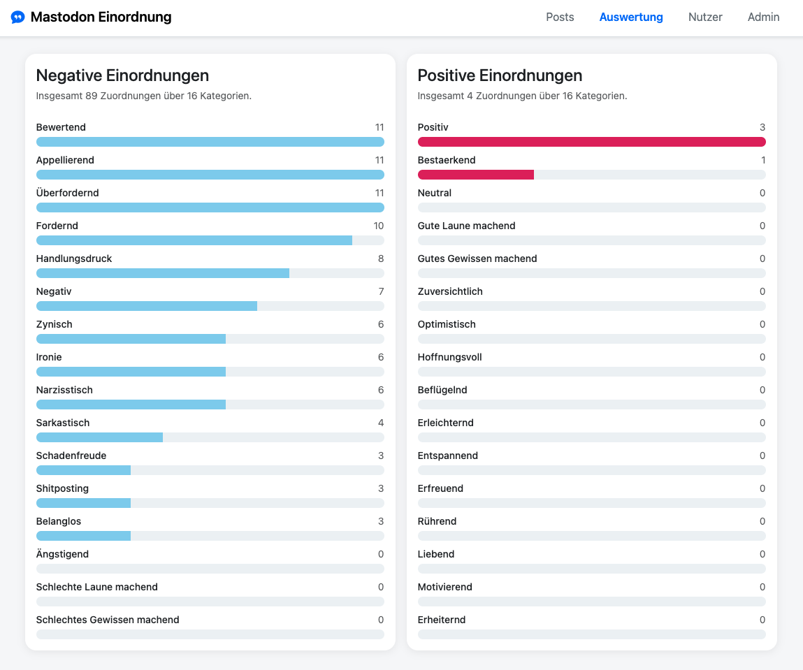
Tag der Wahrheit (nach über 300 Posts) 
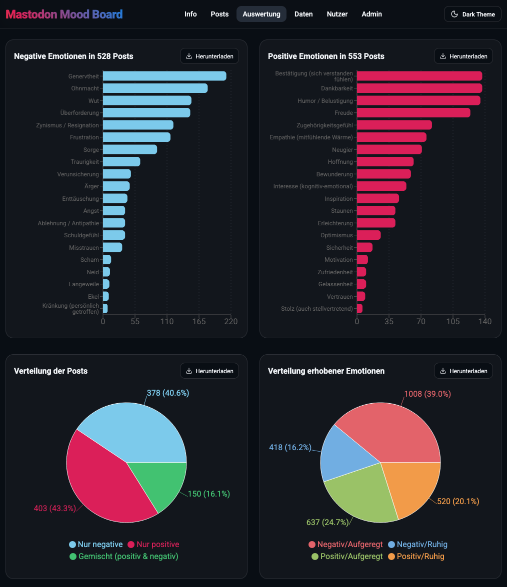
Ja, während des Entwicklungsprozesses habe ich immer wieder Posts eingeordnet. Den Zwischenstand konnte ich als JSON-Datei immer als Backup sichern bzw. exportieren, denn nichts ist ärgerlicher als Datenverlust bei mühsam erhobenen Daten. Ja und was soll ich sagen… lassen wir die Auswertung sprechen.
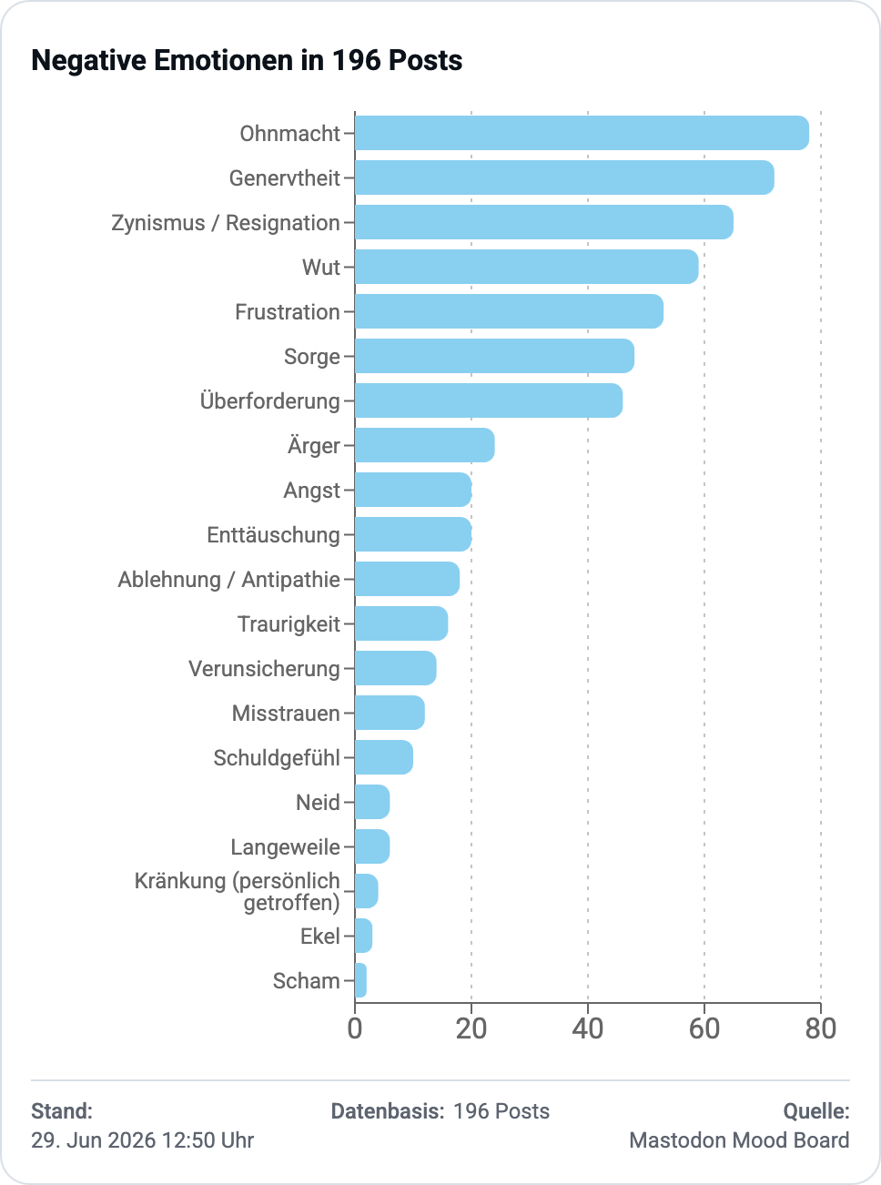
NEGATIVE POSTS
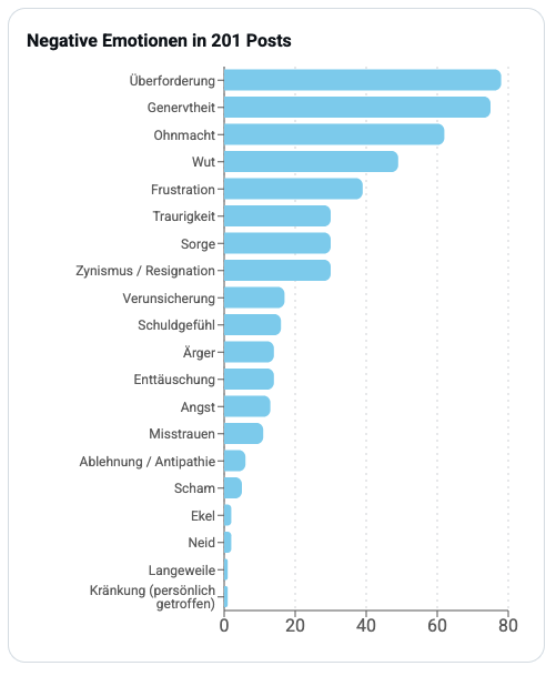
Diese Abbildung zeigt welche negativen Emotionen am häufigsten aufgetaucht sind. Die fünf Top-Emotionen sind hierbei
- Überforderung
- Genervtheit
- Ohnmacht
- Wut
- Frustration
Das genau diese Emotionen soweit oben liegen hätte ich nicht gedacht. Vor allem Überforderung hat mich überrascht. Aber tatsächlich fühle ich mich von vielen Posts überfordert. Sie sind thematisch weit weg von mir, oder auch der räumlich Bezug hat nichts mit meiner Lebenswelt zu tun, aber auch oftmals besserwisserisch daherkommende Posts, die irgendeine exotische Superlösung für ein Nischenproblem zum besten geben, können mich überfordern.
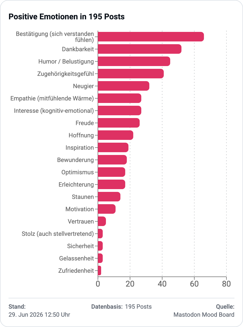
POSITIVE POSTS
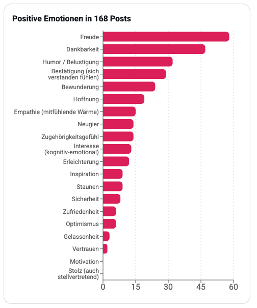
Es gibt sie die positiven Emotionen, soviel ist schonmal schön. Die Top fünf lauten hier
- Freude
- Dankbarkeit
- Humor / Belustigung
- Bestätigung (sich verstanden fühlen)
- Bewunderung
Und das sind auch tatsächlich die Emotionen, nach denen ich mich sehne. Die positivste Erfahrung habe ich mit tollen Fotos von der Natur, Dankbarkeit habe ich z.B. für tolle Links auf sinnvolle/konstruktive andere Inhalte. Bewunderung geht oft einher mit Überforderung, weil Leute Erfolge teilen, die mich selbst überfordern. Manche Posts bringen mich einfach zum Lachen, auch manch schwarzer Humor.
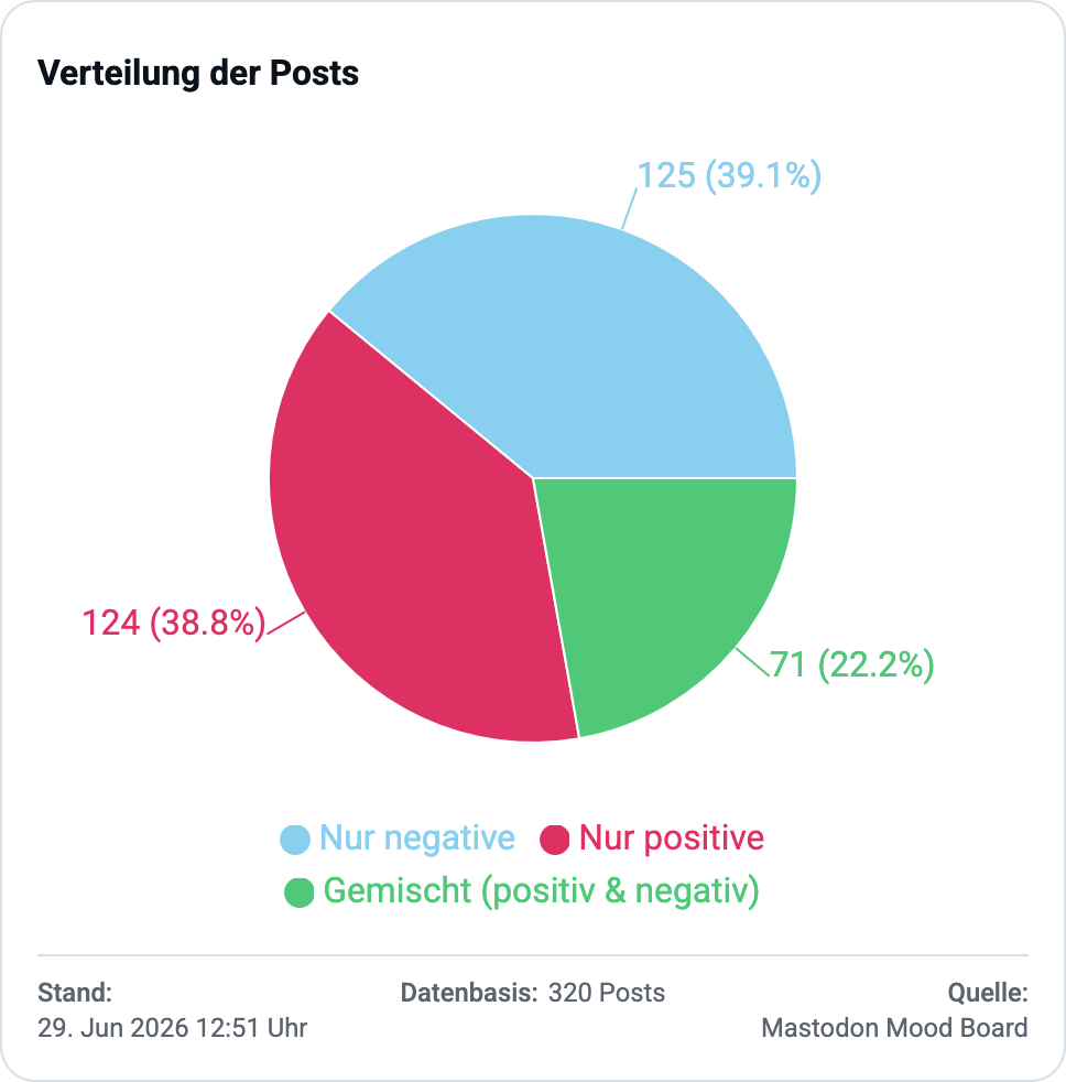
VERTEILUNG AUF POSITIV & NEGATIV
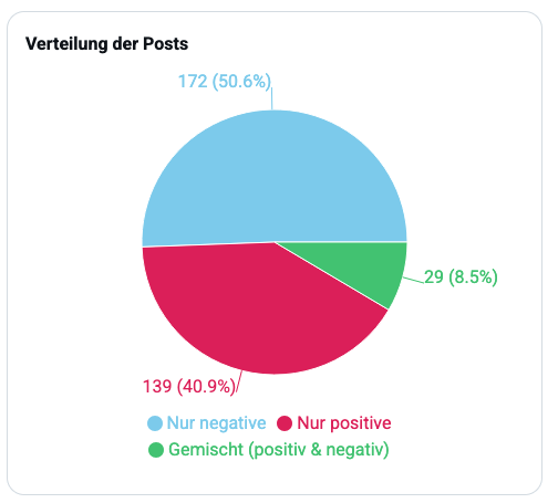
Interessant für mich war letztlich das Verhältnis von Posts die positive Emotionen hervorrufen vs. Posts die negative Emotionen hervorrufen. Und da ist klar erkennbar dass dieses Verhältnis nicht ausgeglichen ist. Nur 40 Prozent (zu diesem Zeitpunkt der Einordnungen, später wurde das etwas besser) rufen ausschliesslich positive Emotionen hervor. Was ich aber noch viel krasser finde ist, dass die Hälfte der Posts ausschliesslich negative Emotionen auslösen. Das bedeutet, die Hälfte der Zeit konsumiere ich Posts die deutlich negative Emotionen hervorrufen. Wow! JETZT WEISS ICH WARUM ICH SCHLECHTE LAUNE BEKOMME.
VERTEILUNG UEBER DIE ZEIT
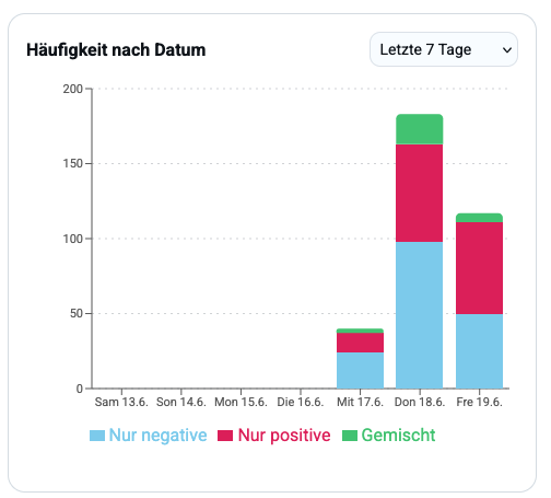
Das ist sicher erstmal nur ein erster Einblick nach knapp 3 Tagen Einordnung. Damit ich das auch mit fortschreitender Zeit im Blick behalten kann, habe ich in der Auswertung auch ein Barchart eingebaut, dass mir die Verteilung Negativ/Positiv/Gemischt auf die Tage runtergebrochen anzeigen kann.
Wie gehts weiter? 
Ich moechte noch ein paar Tage Posts in Ruhe einordnen, auch wenn ich nun schon weiss, dass über 50% mir schlechte Laune machen werden. Das ist sehr viel und das wird Arbeit und Überwindung. Im Gebrauch des Tools stellen sich sicher noch Probleme heraus oder fehlende Funktionen. Aber sobald ich das Gefühl habe die Applikation läuft richtig gut rund, moechte ich sie für die Allgemeinheit kostenlos bereitstellen.
Aus meiner Sicht sollte jeder für sich selbst einmal schauen, ob sein Social Media Gebrauch (noch/jemals) gesund für ihn oder sie ist/war. Ich hab da so meine Zweifel. Für mich ist jetzt schon klar, nach diesem wissenschaftlichen Experiment ist für mich Schluss mit „Social“ Media. Ich moechte nicht über 50% negative Emotionen haben, so einfach ist das!
 Eine Regel scheint allerdings noch besser oder mindestens genausogut geeignet die negativen Auswirkungen von Social Media zu begrenzen, nämlich eine Beschränkung der Verweildauer des Nutzers. In Diskussionen und Studien werden Zahlen von teilweise durchschnittlich 3,5 Stunden Verweildauer pro Tag genannt. Das eine so lange Beschäftigung mit nur einer Sache nicht zur Gesundheit beiträgt erscheint intuitiv klar.
Die Verweildauer könnte man ohne Alterskontrollen problemlos begrenzen auf der Anbieterseite. Ich sehe ad hoc folgende Möglichkeiten:
- Uhr mit einem Zeitbudget:
Es läuft eine Uhr mit einem Zeitbudget während der Nutzung runter. Dabei wird das Zeitbudget zentral auf Anbieterseite gemessen und begrenzt. Leider lässt das Tür und Tor offen für Umgehungsmassnahmen, z.B. einfach Mitglied in mehreren Social Media Diensten sein, dann kann man da auch weiteres Zeitbudget bekommen. - Zeitbudget pro Gerät:
Das scheint mir die technisch zuverlässigste Herangehensweise. Apple und Google könnten z.B. alle Apps die als Social Media Apps einklassifiziert sind in der Nutztungszeit überwachen (das tun sie derzeit bereits) und transparent das verbleibende Social Media Zeitbudget anzeigen. Nach z.B. 1h Nutzung ist Schluss für 24h.
Das sind natürlich technische Lösungen für ein primäres Problem der Selbstdisziplin und des bewussten Umgangs mit eine potenziellen Droge. Eine technische Lösung kann man immer umgehen, sie erhöht lediglich die Kosten für den Abhängigen, um „an den Stoff zu kommen“. Der einzige Schutz ist meiner Ansicht nach wirklich Einsicht und eben Fakten die es einemschwarz auf weiss bzw. in bunten Charts zeigen, was da nicht gesund ist. Mit dieser Einsicht, ist es dann eine bewusste Entscheidung zur Selbstschädigung.
 Mir ist klar geworden, dass mein eigener Social Media Gebrauch für mich aus zwei Gründen problematisch ist:
Grund 1 im Durchschnitt lösen die Posts die ich lese deutlich mehr negative Emotionen aus als ich mir eingestehen wollte. Und die wenigen positiven posts, gleichen das bei weitem nicht aus.
Grund 2 besteht in der aktuell zeitlich unbegrenzten Nutzung bzw. der einfachen Zugänglichkeit/Verfügbarkeit, ich muss mir selbst eine harte Zeitbegrenzung setzen und die Kosten erhöhen (z.B. keine Apps für Social Media mehr, nur Webbrowser auf dem Desktop ab und an), denn damit reduziere ich auch den Zeitraum effektiv in dem mir Social Media Schaden zufügen kann.
Update: 5 Tage später 
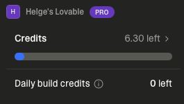 Meine Credits bei Lovable sind von anfangs 100 CREDITS auf nunmehr 6.30 CREDITS zusammengeschrumpft. Ich habe trotz all der Hilfe durch die AI die den Code geschrieben hat, den Eindruck ich habe ziemlich hart gearbeitet.
Ich habe eine „Bildbeschreibung“ nach der naechsten geschrieben. Meine Deutschlehrerin wäre stolz auf mich, soviele Bildbeschreibungen habe ich geschrieben! Ich hab das alles dokumentiert. Ich habe ca. 50 Prompts in 5 Tagen abgesetzt. Vermutlich bin ich ein krasser Underperformer verglichen mit Leuten wie Peter Steinberger, die wochenlang mehrere Systeme gleichzeitig mit Prompts beschickt haben um am Ende OpenCLAW zu präsentieren.
Die „Bildbeschreibungen“ aka Prompts waren umfangreich und komplex. Man kann nicht einfach schreiben: „Entwickle mir bitte dieses Tool das es noch nicht gibt, das es noch nie gab und von dem ich gerade selbst nicht weiss wie ich es umsetzen soll.“ So funktioniert es nicht. Die wichtigsten Ressourcen waren:
- Eine starke Idee mit konkretem Ziel
- Jede Menge Vorstellungskraft was sein könnte, wenn…
- Tonnenweise Erfahrung in der Softwareentwicklung (z.B. TechStacks für Datenhaltung und UI rund um Webdevelopment, Security-Aspekte im WWW), um nicht von Beginn an in einer technischen Abhängigkeit zu landen aus der man sich nicht mehr (oder nur zu hohen Kosten) lösen kann später. Das wird tatsächlich bereits beim allerersten Prompt dringend benötigt, sonst landet man in der Abhängigkeit des Anbieters (hier lovable.dev)
- Präzise Formulierungen mit exakten Bezugnahmen um Missverständnisse und nutzlose AI-Arbeit zu vermeiden.
- Vorgaben machen: Alles was man implizit meint und als selbstverständlich annimmt, sollte man besser unbedingt explizit machen (oder sich halt überraschen lassen was passiert und Goodbye zu den CREDITS sagen die das gekostet hat.)
- Damit sind wir beim Ökonomischen Teil: KEINE CREDITS verschwenden für Tüdelkram. Lieber den Tüdelkram im Rahmen des nächsten dicken Prompt mit erledigen lassen. So habe ich sehr effizient arbeiten können.
Es hat glaube ich 20 Prompts gebraucht bis ich ein Feature entdeckte das sich „Plan“ nennt und nicht „Build“. Bei „Plan“ analysiert die AI erstmal deinen Prompt und gibt ne Rückmeldung dazu, ohne irgendwas zu bauen. Das Dumme daran (so zumindest mein derzeitiger Eindruck) ist: Es kostet dich fast so viele CREDITS wie das Bauen an sich. Also habe ich genau einmal wenig „Plan“ und sonst immer meist nur „Build“ benutzt.
Mindestens zweimal habe ich aus Versehen die RETURN-Taste getroffen im Eingabefeld und der Prompt zum Bauen ging los obwohl er noch nicht fertig war. Joa, ’ne unvollständige Bildbeschreibung führt zu nix, aber kostet gut CREDITS. Leider hat es gedauert, bis ich die STOP-Taste zum Abbrechen eines Build gefunden habe. Seitdem formuliere ich meine Prompts in einem externen Texteditor und kopiere sie wenn sie fertig sind in das Eingabefeld von Lovable.dev. Ich finde das echt unglücklich gemacht vom Anbieter, den die RETURN-Taste ist so fix aus Versehen getroffen und das Absenden kostet halt gleich mal echtes Geld. Da will man sich schon sicher sein. Eine kurze Rueckfrage vorher wäre hilfreich, bevor man den Prompt wirklich lossendet.
Irgendwann so nach etwa 40 Prompts habe ich die AI die eigene Codebasis auf Refactoringpotenzial untersuchen lassen. Das hat satte 6 CREDITS gekostet und dann kam ein umfangreicher Plan mit möglichen Massnahmen zurueck. Wer mal selbst ne grössere Codebasis betreut hat, der weiss zu schätzen, dass hier ein ganz konkreter Massnahmenplan geliefert wird. Ich war schwer beeindruckt. Ich habe nicht allen Massnahmen zugestimmt (denn nicht alles war wirklich nötig), dann aber einige weitere CREDITS ins Refactoring versenkt um Altlasten zu bereinigen und Sachen konsistenter zu machen. Letztlich moechte ich die Codebasis ja selbst verstehen können und wo nötig selber Hand anlegen können, zumindest aber eine überschaubere Ausgangslage für ein Codereview haben.
UPDATE: 29. Juni 2026 
Ich habe zwischenzeitlich weiteres Geld investiert (einmal 25 EUR um nochmal 100 CREDITS zu bekommen + nochmal 15 EUR für 50 CREDITS). Ich gebe zu das ist ein wenig süchtig machend. Vor allem, weil meine Vorstellungskraft, was als naechstes sinnvoll wäre um es ebenso zu entwickeln, da einfach weiter arbeitet. Da das Kodieren als Problem durch AI gelöst scheint, kann ich also rein inhaltlich arbeiten. Einerseits toll, andererseits wird mir klar, das war es mit meiner Welt als Software Entwickler wie ich sie kannte. Doch das Resultat ist einfach soooo gut geworden: 25 + 25 + 15 = 65 EUR für fünfundsechzig Euro habe ich ein Tool in der Hand, mit dem ich eine lange gehegte Idee in einer knappen Woche umgesetzt habe.
Da ich früh im Prozess die Releases (Buildnummer) bei jeder akzeptierten Änderung (deployment-ready) um EINEN Zähler erhöht habe, weiss ich jetzt, das ich mindestens 82 Prompts gesendet habe. Meine Prompt History habe ich mir notiert, denn sie ist ja in meinem Text-Editor vorhanden.
 Ich habe aber nicht nur lovable.dev selbst benutzt. Für kleinere Fragen und Ausprobieren von z.B. statistischen Berechnungen auf meinen Daten, habe ich gerne auf perplexity.ai zurueckgegriffen. U.a. habe ich mit perplexity.ai eine Berechnungslogik für die gesundheitlichen Metriken zur Bewertung des aktuellen Social Media Feed erarbeitet. Zwischenzeitlich habe ich Code-Schnippsel in einem Jupyter Notebook händisch aufbereitet und modifiziert. Da ich Python gut beherrsche und Jupyter Notebooks eine gute Umgebung sind schnell mal was mit Daten auszuprobieren, war das bei dieser Art Berechnungen sehr gut das selbst machen zu können. Ich moechte da auch nicht blind der AI vertrauen, wenn es um Gesundheitsmetrik geht. Und ich war auch immer wieder auf der Webseite von ReCharts dem Framework, das ich für die Charts in der Applikation einsetze. ReCharts hat eine ganz gute Seite mit Beispiel-Charts, die sehr hilfreich ist.
Ein guter Zugang zu den erhobenen Daten über Charts war mir sehr wichtig. Die low-hanging-fruits sind erstmal Verteilungen anzuzeigen. Das gibt auch wirklich schon einen guten Eindruck. Doch ich wollte ein wenig mehr rausholen. Mich interessierte, ob ich die Accounts von Autoren verorten kann. Denn aufgefallen war mir schon, dass einige Accounts eher konsistent zu schlechten Gefühlen führen. War das immer so (geringe Standardabweichung der Emotionen vom Durchschnitt)? Gab es besonders positive Autoren (Mittelwerte im Bereich positiver Valenz)? Und genau das habe ich dann mit einem passenden Chart dazu einbauen können.
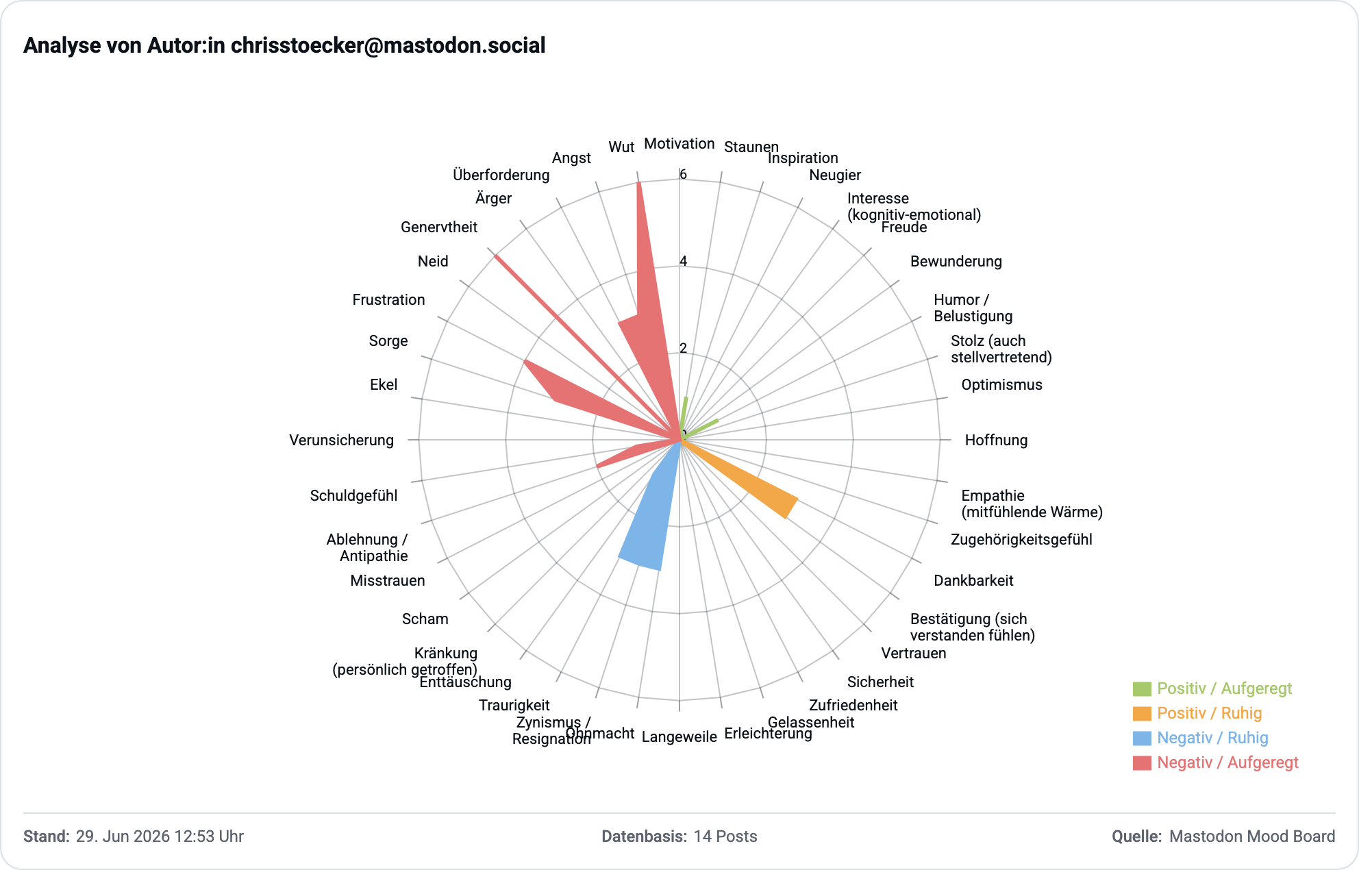
Beispiel: Christian Stöcker 
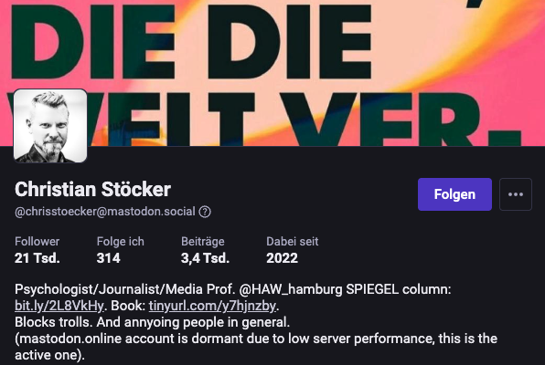
Christian hat über 21.000 Follower auf Mastodon. Ich bin einer davon. Folgende zwei Diagramme zeigen, wo mein Mastodon Mood Board ihn nach einigen Posts verortet. Die erste Abbildung zeigt die Einordnung anhand des Durchschnitts der Erregung und der Valenz die Posts von ihm durchschnittlich bei mir ausgelöst haben. Eine hohe Erregung kann okay sein, aber wenn die Valenz dazu negtaiv ist (es sich also um negative Gefühle handelt), dann ist das nicht mehr so gut.
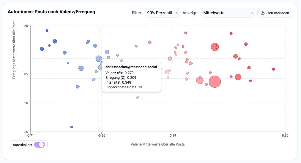
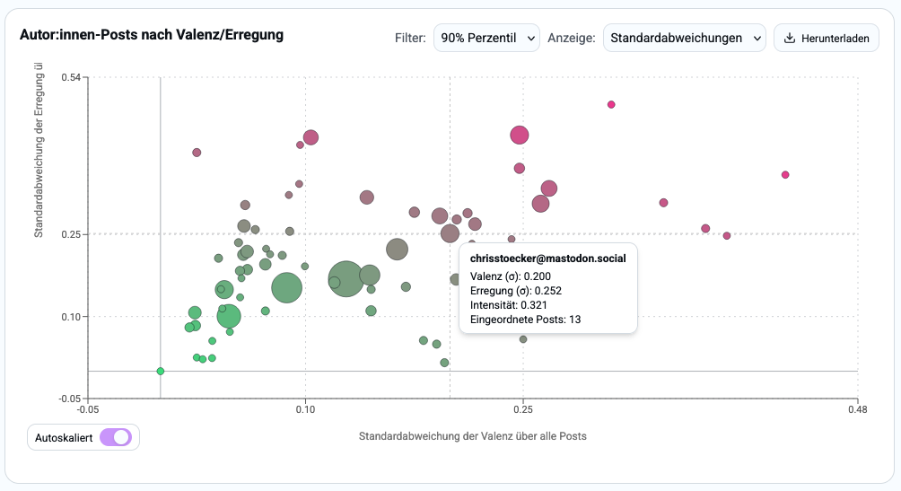
Das zweite (folgende) Chart zeigt, ob die Posts immer so konsistent in dem obigen Bereich der Erregung/Valenz landen, oder ob es auch (in diesem Fall) positive Ausreisser gibt. Die Streuung der Valenz ist geringer als die Streuung der Erregung. Es sind also meistens konsistent negative Gefühle, die Posts von ihm bei mir hervorgerufen haben. Hinweis für das Ablesen der Charts: Die linke, obere, abgerundete Ecke der Einblendung zu dem Datenpunkt zeigt auf den Kreis unmittelbar daneben, um den es geht.
Wichtige Auswertungen & Features die nun verfügbar sind 
Das Mastodon Mood Board hat sich schnell weiterentwickelt. Hier nun eine Übersicht der wichtigsten Neuerungen die ich in der Zeit hinzufügen konnte:
LISTE DER FUNKTIONEN DIE DAS MOODBOARD NUN BESTIMMEN
- Die erste Seite bzw. das On-Boarding wurde deutlich verbessert/verschönert
- Es wird knapp aber klar erklärt was das Tool leisten soll
- Von dort wird man direkt in den Posts-Bereich weitergeleitet
- Posts
-
- Man kann den Bereich zur Verbindung mit einer Instanz jetzt einklappen (man braucht das ja meist nur einmal)
- Es gibt jetzt eine Gesundheits-Metrik, die für den aktuellen Tag Indizes berechnet, die einen früh warnen sollen, dass etwas nicht mehr gesund für einen ist
- Die Gesundheitsmetrik kann am unteren Rand fixiert werden, so dass man während man in Posts scrollt, diese immer im Blick hat
- Die Posts zeigen auch Metadaten an wie z.B. Anzahl Antworten, Boosts, Quotes, Favs und geben Hinweise darauf, ob ein Post eine Antwort auf jemand anderes ist
- Auswertung
-
- Chart und Filter zu Betrachtungszeitraum für Auswertung und Verteilung der Posts
- Charts zu positiven und negativen Emotionen in der Verteilungsübersicht
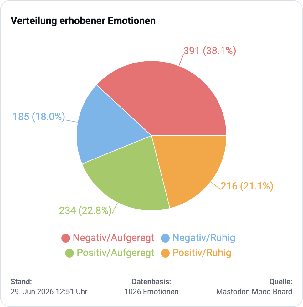
- Kreisdiagramm zur Verteilung der Posts auf positiv/negativ/gemischt
- Kreisdiagramm zur Verteilung der Emotionen nache Emotions-Quadrant (Valenz/Erregung)
- Scatter-Chart zur Einordnung der Autoren nach ihren durchschnittlichen Werten über all ihre Posts (Mittelwerte und Standardabweichungen) mit Filteroption nach Perzentilen (Ausklammern von Autoren von denen wenig Posts vorliegen)
- Radar-Chart das die Autorenprofile visualisiert anhand des vollen Emotion-Circumplex (4-Quadranten-Schema)
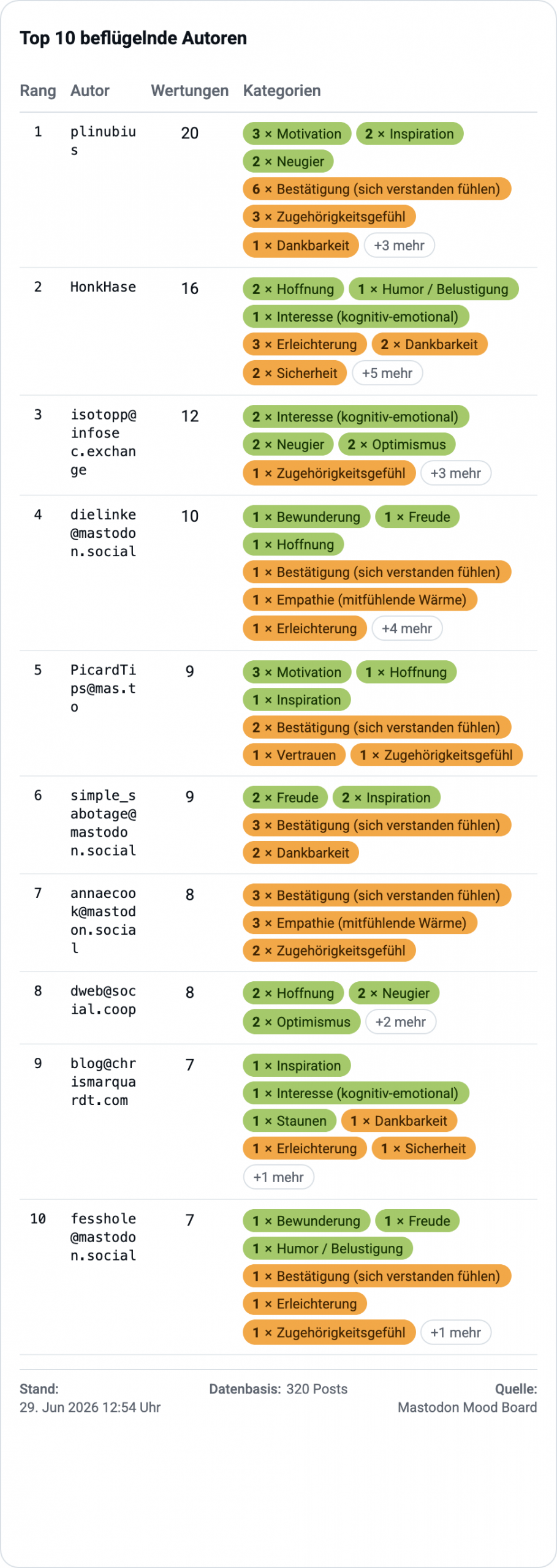
- Tabelle bzw. Liste der Top 10 belastenden und beflügelnden Autoren
- Alle Diagramme sind exportierbar als (PNG, PDF, CSV, Excel und JSON)
- Alle Auswertungen beziehen sich auf die im localStorage gespeicherten Daten
- Daten
-
- Tabellarische, rückwärts-chronologische Liste der gespeicherten und eingeordneten Posts, die man notfalls vollständig expandieren kann. Das ist hilfreich, um Sachen nachschauen zu können oder Einordnungen zu korrigieren. Hier wünsche ich mir noch eine Volltext-Such-Funktion nach Autor und Postinhalt und eine Filterfunktion nach Emotionen und Zeitraum
- Export aller Daten als JSON Datei. Das ist supernützlich als Backup und um es mit anderen teilen zu können. Das human-readable JSON lässt sich schnell anonymisieren und für weitere Auswertungen einsetzen. Es war megahilfreich bei der Entwicklung, um mit Python und Data Science auf den Daten z.B. im Jupyter Notebook zu arbeiten.
- Import eines Datensatzes. Ist superhilfreich, z.B. wenn man von einer gehosteten Instanz des Mood Board in eine andere „umziehen“ will. Einfach das Archiv importieren und dort weitermachen wo man aufgehört hat. War superhilfreich bereits bei der Entwicklung.
- Alle Daten löschen. Löscht wirklich alles im localStorage, das ist supernützlich, falls man auf die Nutzung eines Browsers/Computers angeweisen ist, über den man keine Kontrolle hat (fremdbestimmt). So schützt man seine Daten nachhaltig, erst exportieren, dann im Browser alles löschen!
- Nutzer
-
- Den Namen ändern können ist nett, wenn man z.B. Screenshots macht die den Namen beinhalten sollen.
- Zeichenlimit für die Anzeige von Posts. Das ist leider notwendig, weil einige Posts ganze Kurzgeschichten sind und das gesamte Layout sprengen können. Hier legt man das Limit selber fest und beugt der Layoutsprengung vor. Gleichzeitig ist es ein guter Schutz vor Posts die die Post-Länge missbrauchen für ellenlage Texte die der Idee des Microblogging meiner Ansicht nach zuwider laufen.
- Nutzerhilfe ist der Versuch ein wenig Erklärung zu der Applikation anzubieten. Derzeit nicht 100 Prozent aktuell, da die Applikation schnell gewachsen ist, und die Änderungen noch nicht alle in der Hilfe angekommen sind, aber besser als nix erstmal.
- Admin
-
- Der Admin-Bereich sollte nur im Spezialfall betreten werden, da hier bereits sinnvolle Default-Werte gesetzt sind, deren Veränderung massive Auswirkungen haben können (WARNUNG: Das wurde bislang noch nicht getestet, was für Auswirkungen da alles auftreten könnten)
- Steht man am Beginn seiner Aufzeichnungen mit dem Mood Board, kann man hier händisch selbst ein Emotionsset auflegen und konfigurieren. Man sollte sich aber über das Valence-Arousal-Schema nach Russel informieren und gültige Werte dafür einsetzen.
- Nachträgliche Änderungen des Namens, des Arousal, der Valence und der Positiv/Negativ-Zuordnung einer Emotion, können und werden signifikante Auswirkungen auf die Auswertung haben und diese vermutlich ungültig bzw. wissenschaftlich gesehen nutzlos machen.
Beispiele für visuelle Hilfen an den Nutzer bei der täglichen Einordnung 
Tages-Risiko-Index
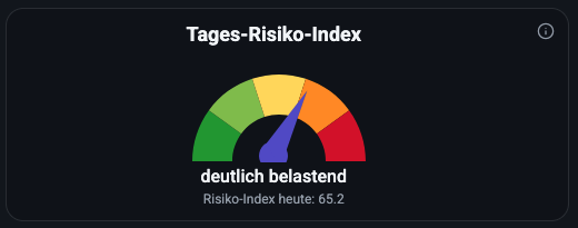
Der Index ist eine Berechnung auf Basis einiger Kennzahlen über die am jeweiligen Tag eingeordneten Posts. Er bezieht die Varianzen der Posts in den Emotionen ebenso ein wie die Häufigkeiten der positiven wie negativen Emotionen und deren Intensität auf der Valenz/Arousal-Skala.
Indikatoren zur Feed-Qualität
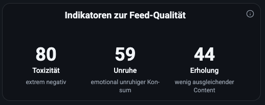
Die drei Indikatoren geben Anhaltspunkte wie stark die Posts die man eingeordnet hat ein konstant negatives Emotionsspektrum zeigen (Toxizität) aber auch wie stark divers die Emotionen sind, also ob es eher eine konsistente Emotionslage ist oder stark abwechselnd (Unruhe). Posts, die positive Valenz zeigen und z.B. auch Ruhe ausstrahlen (geringe Erregungswerte) können einen Beitrag zur Erholung liefern und als ausgleichender Content bewertet werden.
Beispiele für visuelle Hilfen an den Nutzer in der historischen Gesamtschau 
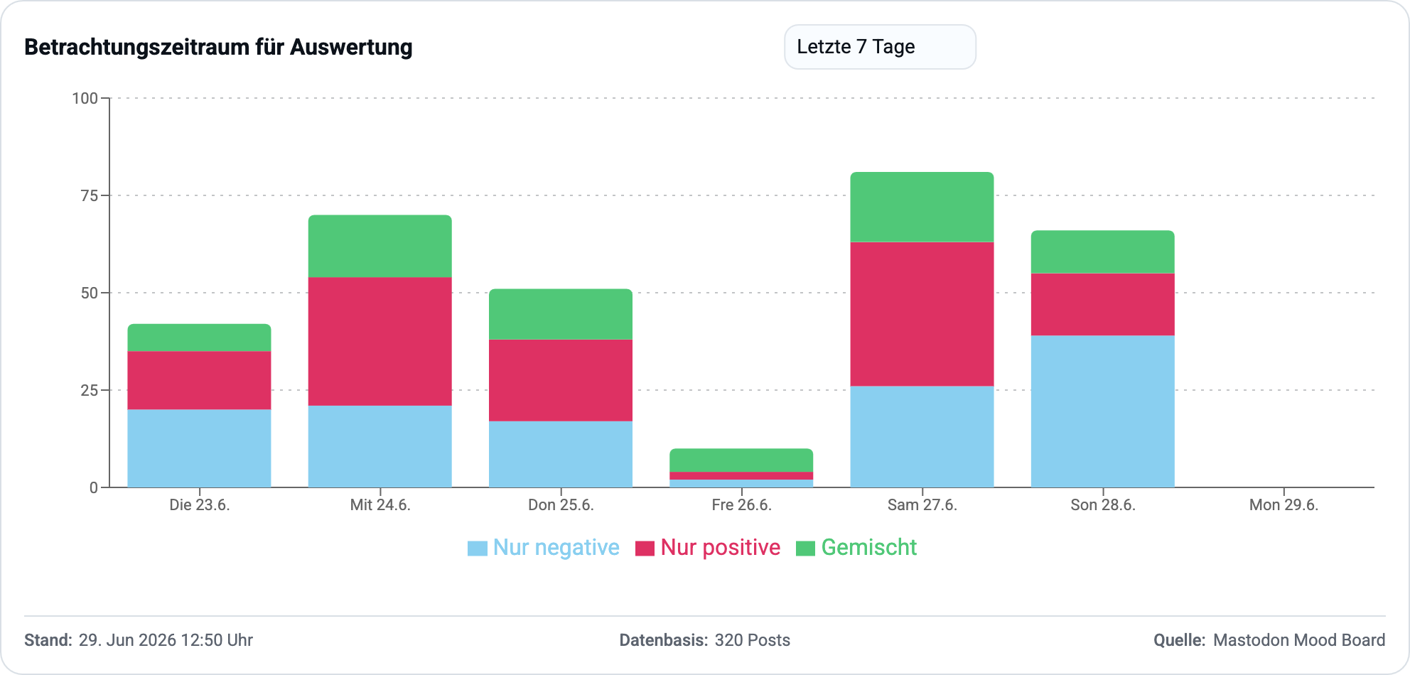
Betrachtungszeitraum für Auswertung
Dieses Chart zeigt eine gute Übersicht, an welchen Tagen Posts eingeordnet wurden. Gleichzeitig kann man den Betrachtungszeitraum für die gesamten Charts festlegen, die die Applikation im Auswerten Bereich zur Verfügung stellt. Man auch nur den aktuellen Tag auswählen, um eine Auswertung ausschließlich der letzten Aktivitäten zu bekommen.
Negative Emotionen
Das Chart liefert eine Häufigkeitsverteilung der genannten negativen Emotionen, sortiert absteigend.
Positive Emotionen
Das Chart liefert eine Häufigkeitsverteilung der genannten positiven Emotionen, sortiert absteigend.
Verteilung der Posts
Manche Posts rufen sowohl negative als auch positive Emotionen hervor, diese werden in der Verteilung als „Gemischt“ bewertet, so kann man sehen wieviel ambivalent bewertete Posts es gibt und welchen Anteil sie ausmachen.
Verteilung erhobener Emotionen
Dieses Tortendiagramm schlüsselt die vergebenen Einordnungen nach den Quadranten für Arousel und Varianz auf. Damit erhält man einen guten Einblick welche Art Emotionen die Mehrheit stellen und welchen Anteil sie insgesamt haben.
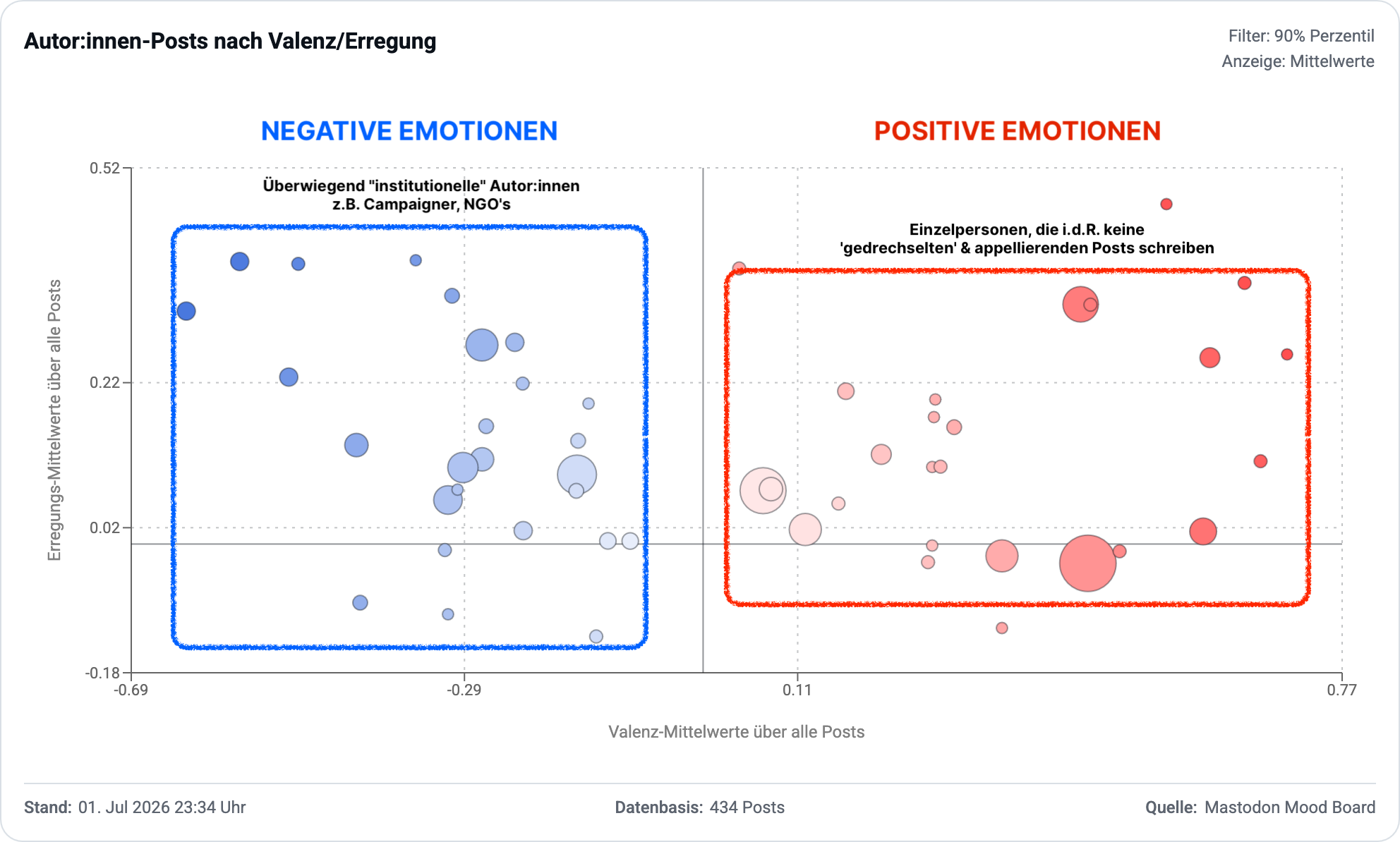
Autor:innen-Posts nach Valenz/Erregung (Mittelwerte)
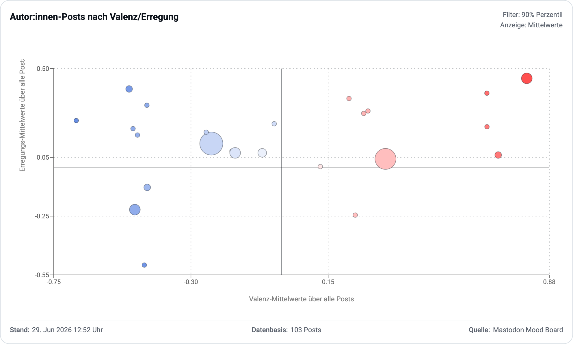
Das hier ist eines der interessanteren Charts, denn es ermöglicht einen Einblick, wer die Autor:innen sind, die für überwiegend negative Gefühle verantwortlich sind. Die Größe der Bubbles zeigt an, wie häufig es Posts von diesen Autoren gab, die eingeordnet wurden. Welchen Anteil am Feed sie auch haben. Ist die Bubble groß, gab es viele Posts von diesem Autor.
Bubbles die in diesem Chart in der linken Hälfte liegen, erzeugen im Durchschnitt negative Emotionen, liegen die Bubble rechts, sind es im Durchschnitt positive Emotionen. Liegt die Bubble oberhalb der horizontalen Nullinie, dann sind die Posts eher aufregend gewesen, liegen die Bubble unterhalb der Linie dann sind die Posts eher beruhigend bis lethargisch machend gewesen.
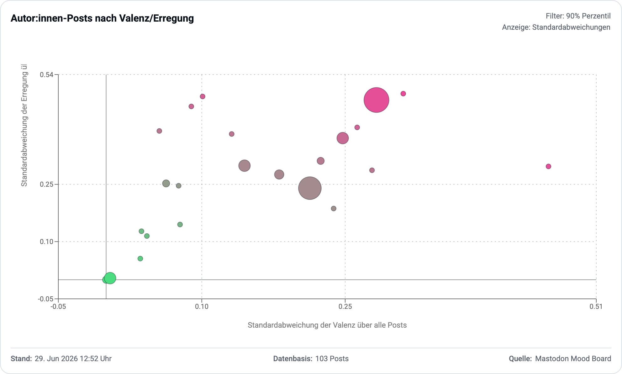
Autor:innen-Posts nach Valenz/Erregung (Standardabweichungen)
Schaltet man die Ansicht von den Durchschnittswerten um auf die Standardabweichung, dann werden die Bubbles umsortiert zu diesem Chart. Je näher die Bubbles in der linken unteren Ecke verortet sind, umso geringer ist ihre Abweichung vom Mittelwert. Das kann man so interpretieren, dass der Autor sehr konsistent immer wieder das gleiche durchschnittliche Emotionslevel hervorruft.
Ist die Bubble eher rechts oben verortet, dann sind die Posts des Autors stark variierend, mal sind sie positiv, mal negativ, wenn die Bubble weit rechts liegt, mal sind sie aufregend mal beruhigend wenn sie sehr weit oben liegt.
Wichtig: Autoren, die bei den Mittelwerten (vorheriges Chart) in der linken Hälfte liegen und hier in der unteren linken Ecke, liefern konsistent negative Emotionen. Da sollte man überdenken, ob man sich das weiter antut.
Analyse von Autor:in
Besonders aufschlussreich ist es einen Autor nach seinem Emotionsprofil zu untersuchen. Das ist allerdings erst nach einigen eingeordneten Posts wirklich aussagekräftig. Je mehr Posts dieses Autors eingeordnet wurden umso besser gibt dieses Profil die mit diesem Autor verbundenen Emotionen wieder.
Das ist keine Aussage über das zukünftige Verhalten des Autors und der Wirkung seiner Posts, aber es gibt einen guten Überblick wie die Posts in der Vergangenheit gewirkt haben.
Top 10 belastende Autoren & Top 10 beflügelnde Autoren
Aus Datenschutzgründen, habe ich die belastenden Autoren hier nicht genannt. Eine simple Auszählung der Posts aller Autoren und eine Sortierung nach den Autoren die die positivsten Einordnungen hatten, liefert am Ende eine Liste an Autoren die verantwortlich sind für die eigenen positiven Emotionen. Diese Autoren bereichern den Feed positiv.
Mood Board App 
Bereit die Applikation selbst mal auszuprobieren? Dann klicke folgenden Link:
FAZIT 
Ich habe für 65 EURO plus meiner Arbeitszeit von ca. 1 Woche (ohne Wochenendpause) eine voll funktionsfähige Applikation.
Ich habe über 800 Posts bewertet in dieser Zeit. Und ich habe Erkenntnisse gewonnen, die mir die Problematik dieses Mediums vor Augen führen.
Ich kann nun auf der Basis dieser Erkenntnisse meine eigenen, privaten Schlüsse ziehen und auch mein Handeln anpassen. Und das moechte ich als naechstes tun. Und ich moechte das Tool auf die eine oder andere Art und Weise anderen zur Verfügung stellen, um unabhängig von irgendwem, selber zu Einsichten zu gelangen. Ich weiss leider noch nicht wie ich das machen sollte. Ich hoffe ich finde eine passende Lösung.
Wer bis hier echt gelesen hat: Hut ab, mein Respekt. Das Schreiben dieses Beitrag war unglaublich kräftezehrend. U.a. weil Bilder einbinden immer noch nervige Arbeit ist in WordPress, weil ich eine custom Lösung für die Prompts brauchte (EIN-AUSKLAPP-Mechanismus) und weil ich wirklich lieber an dem Tool gearbeitet habe, als das hier alles dokumentieren zu wollen.
Von daher gilt: „Sorry, dass ich so einen langen Blogpost schrieb, ich hatte keine Zeit für einen kurzen Blogpost!“
Nachtrag: Persönliches Fazit 
Die zentrale Erkenntnis aus der Selbsterforschung meines Mastodon Feed ist für mich, dass es überwiegend Accounts sind, die institutionell und/oder aus beruflichen Gründen betrieben werden, die problematischen Content in den Feed spülen – auch „über Bande“ durch Boosts von Menschen denen ich folge.
Die dicken, blauen Bubbles in dem folgenden Chart gehören fast ausnahmslos zu solchen Accounts bei mir im Feed. Ein Merkmal in der Mastodon Software wie „beruflicher oder institutioneller“ Account könnte neue Chancen zur Gestaltung bieten, z.B. institutionellen Content konsequent ausblenden zu können. Das dürfte aber genau diesen Accounts nicht gefallen, denn die Suchen ja gerade die magische „Reichweite“.
Mir ist jetzt recht klar geworden wo meine Probleme mit „Social“ Media liegen, ganz unabhängig von der Technologie. Es scheint vollkommen egal zu sein, ob das Mastodon oder Twitter/X oder BlueSky oder sonstwas ist.
Dieser strukturelle Ansatz mit alarmistischen Posts Aufmerksamkeit zu triggern, um Boosts zu bekommen, die noch mehr Aufmerksamkeit einsammeln sollen der macht es institutionellen bzw. Berufs-Social-Media-Beauftragten viel zu einfach. Bezieht man jetzt noch ein, dass es auch immer ein AI/Bot sein könnte der da gerade gesendet hat…
…ja, ich sag mal so, wenn die positiven Effekte so groß wären, dass die toxischen Anteile in der Timeline/Feed deutlich überkompensiert würden, könnte man sich das überlegen es weiter zu benutzen aber so funktioniert es leider nicht. Wenn ich negativ getriggert werde, kann ein positiver Post das nicht einfach weg-kompensieren. Das ist so mein persönliches Gefühl. Das Negative bleibt da und wirkt weiter, es hat eine Abklingkurve (Hysterese) die Zeit braucht.
Why do I blog this? Ich finde man sollte nicht hilflos daneben stehen, wenn einem die Laune immer schlechter wird. Ich hatte Social Media im Verdacht und das was ich hier sehe scheint mich darin zu bestätigen, dass die Inhalte dort alles andere als Gute Laune-Macher sind. Im Gegenteil! Aber es ist auch mitnichten der richtige Weg, Menschen die Social Media gebrauchen und/oder produzieren zu beschämen. Die sogenannte Social Media Scham. Zitat: „Die Social Media Scham folgt einer größeren Entwicklung, die strukturelle Probleme privatisiert – und Individuen beschuldigt, statt systemische Veränderungen anzustreben. […]“ und da ist was dran, denn das gleiche Ding fliegt uns gerade mit AI Scham um die Ohren.
